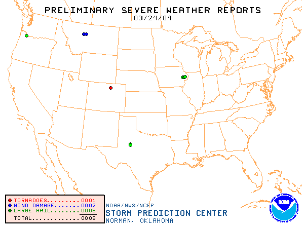
20040324's Storm Reports
|
| Note: All data are considered preliminary |
| Tornado Reports (in CSV format) |
|---|
Time | F-Scale | Location | County | State | Lat | Lon | Comments |
| 2044 | UNK | 1 E JOHNSTOWN | WELD | CO | 4034 | 10489 | (BOU) |
| Hail Reports (in CSV format) |
|---|
Time | Size | Location | County | State | Lat | Lon | Comments |
| 1405 | 175 | MECHANICSVILLE | CEDAR | IA | 4190 | 9125 | UP TO GOLFBALL SIZE HAIL COVERING THE GROUND BY PUBLIC REPORT RELAYED BY KCRG TV. (DVN) |
| 1426 | 100 | 3 E CLARENCE | CEDAR | IA | 4189 | 9100 | (DVN) |
| 1515 | 88 | 6 N WHEATLAND | CLINTON | IA | 4192 | 9084 | (DVN) |
| 1800 | 75 | HAZEL DELL | CLARK | WA | 4568 | 12265 | 3/4 INCH HAIL REPORTED WITH THUNDERSTORM (PQR) |
| 2332 | 88 | DUNN | SCURRY | TX | 3257 | 10089 | HAIL DUNN 32.57N 100.89W 0.75 INCH SCURRY TX (MAF) |
| 0040 | 150 | COLORADO CITY | MITCHELL | TX | 3240 | 10086 | CONTINUOUS LARGE HAIL FOR 14 MINUTES (MAF) |
| Wind Reports (in CSV format) |
|---|
Time | Speed | Location | County | State | Lat | Lon | Comments |
| 2239 | 69 | 1 N GREAT FALLS | CASCADE | MT | 4752 | 11129 | DRY MICROBURST WIND GUST (TFX) |
| 2310 | 58 | HIGHWOOD | CHOUTEAU | MT | 4758 | 11079 | DRY MICROBURST WIND GUSTS BETWEEN 50 AND 60 MPH. (TFX) |
| Full report
in comma-separated values (CSV) format |
| Fields marked UNK are unknown |
| All Times UTC |
| Wind Gusts in MPH |
| Hail Sizes in 1/100 of an Inch (75 = 0.75") |
|
|
|
Top/Storm Reports/Home
|


