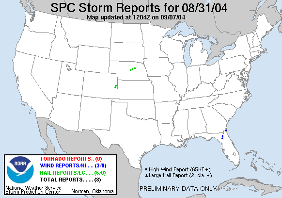
20040831's Storm Reports
|
| Note: All data are considered preliminary |
| Tornado Reports (in CSV format) |
|---|
| No reports received |
| Hail Reports (in CSV format) |
|---|
Time | Size | Location | County | State | Lat | Lon | Comments |
| 2000 | 88 | 16 S BURLINGTON | KIT CARSON | CO | 3907 | 10227 | (GLD) |
| 2041 | 100 | 7 E BURWELL | GARFIELD | NE | 4178 | 9900 | (LBF) |
| 2112 | 100 | 4 S CHEYENNE WELLS | CHEYENNE | CO | 3876 | 10235 | (GLD) |
| 2121 | 100 | 9 NE BARTLETT | WHEELER | NE | 4198 | 9843 | (LBF) |
| 0019 | 75 | 1 SW SARGENT | CUSTER | NE | 4163 | 9938 | MOSTLY 0.25 INCH HAIL (LBF) |
| Wind Reports (in CSV format) |
|---|
Time | Speed | Location | County | State | Lat | Lon | Comments |
| 1735 | UNK | W GAINESVILLE | ALACHUA | FL | 2967 | 8234 | A TREE DOWN ON A HOME AT 2256 UNIVERSITY. (JAX) |
| 1739 | UNK | LAKE BUTLER | UNION | FL | 3002 | 8234 | SOME TREES DOWN ACROSS ROADS FROM LAKE BUTLER TO WORTHINGTON SPRINGS. (JAX) |
| 1930 | UNK | KINGS BAY BASE | CAMDEN | GA | 3079 | 8151 | TREES DOWN ON POWERLINES ACROSS EASTERN CAMDEN COUNTY. (JAX) |
| Full report
in comma-separated values (CSV) format |
| Fields marked UNK are unknown |
| All Times UTC |
| Wind Gusts in MPH |
| Hail Sizes in 1/100 of an Inch (75 = 0.75") |
|
|
|
Top/Storm Reports/Home
|


