|
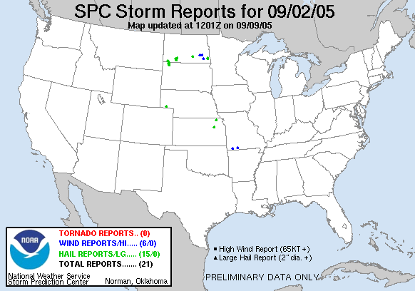
20050902's Storm Reports
|
| Note: All data are considered preliminary |
| Tornado Reports (in CSV format) |
|---|
| No reports received |
| Hail Reports (in CSV format) |
|---|
Time | Size | Location | County | State | Lat | Lon | Comments |
| 1455 | 75 | 15 S NEW LEIPZIG | GRANT | ND | 4616 | 10195 | (BIS) |
| 1730 | 88 | 12 E MOTT | HETTINGER | ND | 4637 | 10207 | (BIS) |
| 1835 | 88 | ELGIN | GRANT | ND | 4640 | 10185 | LASTED 10 MINUTES...FROM 1235 PM MDT TO 1245 PM MDT. (BIS) |
| 0040 | 175 | 14 SE BOWMAN | BOWMAN | ND | 4604 | 10319 | (BIS) |
| 0048 | 175 | 5 W SIDNEY | CHEYENNE | NE | 4113 | 10307 | (CYS) |
| 0140 | 100 | 9 S SCRANTON | BOWMAN | ND | 4602 | 10314 | (BIS) |
| 0200 | 175 | 17 E LUDLOW | HARDING | SD | 4583 | 10303 | (UNR) |
| 0305 | 100 | 1 N RALPH | HARDING | SD | 4578 | 10306 | (UNR) |
| 0355 | 88 | 11 NW PRAIRIE CITY | PERKINS | SD | 4565 | 10296 | (UNR) |
| 0716 | 75 | ALMA | WABAUNSEE | KS | 3902 | 9629 | (TOP) |
| 0915 | 100 | STREETER | STUTSMAN | ND | 4666 | 9936 | LARGE HAIL FELL FROM 415 AM TO 425 AM. (BIS) |
| 0935 | 75 | 7 W FINGAL | BARNES | ND | 4676 | 9794 | (FGF) |
| 1015 | 75 | 7 WSW COLFAX | RICHLAND | ND | 4643 | 9701 | STORMS PRODUCED STRONG WINDS AND 2.5 INCHES OF RAIN. LOTS OF 1 TO 2 INCH BRANCHES BROKEN OFF. (FGF) |
| 1057 | 100 | 7 N GOFF | NEMAHA | KS | 3977 | 9593 | (TOP) |
| 1130 | 88 | 7 SW WALCOTT | RICHLAND | ND | 4648 | 9704 | (FGF) |
| Wind Reports (in CSV format) |
|---|
Time | Speed | Location | County | State | Lat | Lon | Comments |
| 0000 | UNK | 3 E BRANSON | TANEY | MO | 3665 | 9317 | 12 INCH IN DIAMETER TREE BLOWN DOWN OVER ROADWAY. (SGF) |
| 0030 | UNK | 7 SE CASSVILLE | BARRY | MO | 3661 | 9378 | TREE DOWN OVER ROADWAY (SGF) |
| 0915 | 60 | 12 S SANBORN | BARNES | ND | 4677 | 9822 | (FGF) |
| 1030 | 65 | 7 W FINGAL | BARNES | ND | 4676 | 9794 | HIGH WINDS BROKE SEVERAL LARGE BRANCHES DOWN IN FARM YARD WITH A FEW SHINGLES BLOWN OFF SHED. STORM ALSO PRODUCED HEAVY RAINS AND PEA SIZED HAIL. (FGF) |
| 1105 | 62 | LISBON | RANSOM | ND | 4644 | 9768 | (FGF) |
| 1130 | 60 | 12 S SANBORN | BARNES | ND | 4677 | 9822 | (FGF) |
| Full report
in comma-separated values (CSV) format |
| Fields marked UNK are unknown |
| All Times UTC |
| Wind Gusts in MPH |
| Hail Sizes in 1/100 of an Inch (75 = 0.75") |
|
|
|
Top/Storm Reports/Home
|
|


 @NWSSPC