|
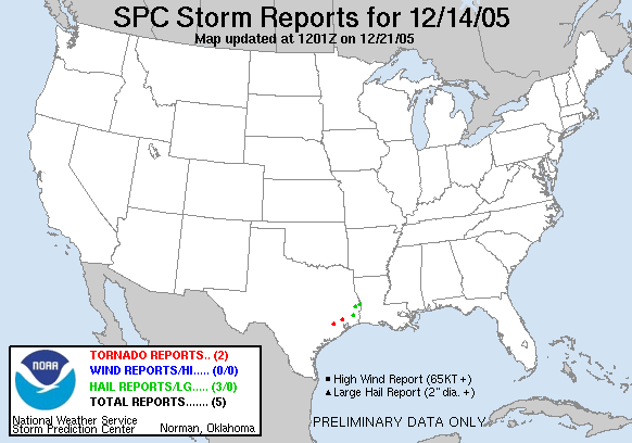
20051214's Storm Reports
|
< 051213 Reports
051215 Reports >
|
|
| Note: All data are considered preliminary |
| Tornado Reports (in CSV format) |
|---|
Time | | Location | County | State | Lat | Lon | Comments |
| 1719 | | 1 SE HUFFMAN | HARRIS | TX | 3001 | 9508 | TORNADO TOUCHDOWN AT 2100 OLD ATASCOCITA ROAD. FLYING ROOF DEBRIS AND SOME DAMAGE TO TREE TOPS. (HGX) |
| 1750 | | 3 SSE KATY | FORT BEND | TX | 2976 | 9580 | LAW ENFORCEMENT PATROL UNIT IN FORT BEND COUNTY REPORTED TORNADO TOUCHDOWN ON STATE HIGHWAY 99 JUST SOUTH OF INTERSTATE 10. (HGX) |
| Hail Reports (in CSV format) |
|---|
Time | Size | Location | County | State | Lat | Lon | Comments |
| 1716 | 100 | JASPER | JASPER | TX | 3092 | 9400 | (LCH) |
| 1735 | 75 | 5 N BURKEVILLE | NEWTON | TX | 3107 | 9367 | (LCH) |
| 1845 | 88 | SILSBEE | HARDIN | TX | 3034 | 9418 | (LCH) |
| Wind Reports (in CSV format) |
|---|
| No reports received |
| Full report
in comma-separated values (CSV) format |
| Fields marked UNK are unknown |
| All Times UTC |
| Wind Gusts in MPH |
| Hail Sizes in 1/100 of an Inch (75 = 0.75") |
|
|
|
Top/Storm Reports/Home
|
|


 @NWSSPC