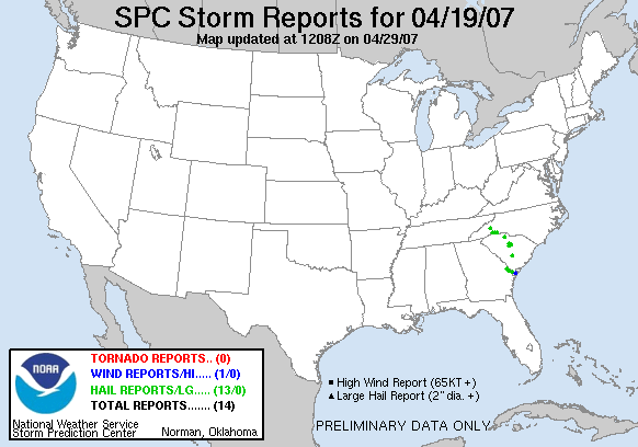
20070419's Storm Reports
|
< 070418 Reports
070420 Reports >
|
|
| Note: All data are considered preliminary |
| Tornado Reports (in CSV format) |
|---|
| No reports received |
| Hail Reports (in CSV format) |
|---|
Time | Size | Location | County | State | Lat | Lon | Comments |
| 1224 | 175 | MCCONNELLS | YORK | SC | 3487 | 8123 | A STORE CLERK IN MCCONNELLS SAID THE HAIL THAT FELL IN THE STORM WAS ABOUT THE SIZE OF GOLFBALLS. (GSP) |
| 1910 | 100 | BLACK MOUNTAIN | BUNCOMBE | NC | 3561 | 8233 | QUARTER SIZE HAIL COMPLETELY COVERING THE ROAD. (GSP) |
| 2034 | 88 | 7 N LANDRUM | POLK | NC | 3528 | 8219 | DIME TO NICKEL SIZED HAIL REPORTED IN THE GREEN CREEK AREA AT THE INTERSECTION OF HWY 14 AND HWY 9 (GSP) |
| 2050 | 88 | 10 E COLUMBUS | POLK | NC | 3525 | 8203 | LOTS OF NICKEL HAIL IN GREEN CREEK (GSP) |
| 2100 | 75 | 10 SE RUTHERFORDTON | RUTHERFORD | NC | 3526 | 8184 | HIGHWAY 221 IN HARRIS (GSP) |
| 2145 | 175 | MCCONNELLS | YORK | SC | 3487 | 8123 | A STORE CLERK IN MCCONNELLS SAID THE HAIL THAT FELL IN THE STORM WAS ABOUT THE SIZE OF GOLFBALLS. (GSP) |
| 2335 | 88 | ORANGEBURG | ORANGEBURG | SC | 3349 | 8087 | SHERIFF OFFICE REPORTED NICKEL SIZE HAIL IN ORANGEBURG. (CAE) |
| 2352 | 75 | BLYTHEWOOD | RICHLAND | SC | 3422 | 8098 | PENNY SIZE HAIL AT BLYTHEWOOD MIDDLE SCHOOL. (CAE) |
| 2355 | 88 | 8 WSW LUGOFF | KERSHAW | SC | 3420 | 8081 | PUBLIC REPORTED NICKEL SIZED HAIL ABOUT 2 MILES NNW OF ELGIN. (CAE) |
| 2355 | 75 | RIDGEWAY | FAIRFIELD | SC | 3431 | 8096 | REPORT OF SMALL BRANCHES DOWN AND PENNY-SIZE HAIL (CAE) |
| 0300 | 150 | NEWINGTON | SCREVEN | GA | 3259 | 8150 | HAIL RANGED IN SIZE FROM DIME TO PING PONG BALL AND LASTED ABOUT 10 MINUTES. (CHS) |
| 0345 | 100 | 4 NNE SPRINGFIELD | EFFINGHAM | GA | 3242 | 8135 | (CHS) |
| 0431 | 100 | HARDEEVILLE | JASPER | SC | 3229 | 8108 | (CHS) |
| Wind Reports (in CSV format) |
|---|
Time | Speed | Location | County | State | Lat | Lon | Comments |
| 0500 | UNK | BLUFFTON | BEAUFORT | SC | 3224 | 8086 | LARGE OAK TREE DOWN IN DOWNTOWN BLUFFTON MAYRIVER ROAD NEAR CALHOUN ST. 1 TREE DOWN IN MAYRIVER PLANTATION. (CHS) |
| Full report
in comma-separated values (CSV) format |
| Fields marked UNK are unknown |
| All Times UTC |
| Wind Gusts in MPH |
| Hail Sizes in 1/100 of an Inch (75 = 0.75") |
| List of Weather Forecast Office 3-letter IDs appear in the report comments section |
|
|
|
Top/Storm Reports/Home
|


 @NWSSPC