|
20161003's Storm Reports (1200 UTC - 1159 UTC) (Print Version)
|
< 161002 Reports
161004 Reports >
|
| Note: All Reports Are Considered Preliminary |
|
|
|
|

| Tornado Reports (CSV) (Raw Tornado CSV)(?) |
|---|
| No reports received |
| Hail Reports (CSV) (Raw Hail CSV)(?) |
|---|
Time | Size | Location | County | State | Lat | Lon | Comments |
| 1855 | 100 | TORRINGTON | GOSHEN | WY | 4207 | 10418 | (CYS) |
| 1857 | 100 | TORRINGTON | GOSHEN | WY | 4207 | 10418 | (CYS) |
| 2102 | 100 | 2 N ALLIANCE | BOX BUTTE | NE | 4213 | 10287 | (CYS) |
| 2105 | 150 | 7 N ALLIANCE | BOX BUTTE | NE | 4220 | 10287 | ALONG HIGHWAY 87. (CYS) |
| 2153 | 150 | 11 NNW IMPERIAL | CHASE | NE | 4066 | 10172 | (LBF) |
| 2243 | 100 | 1 N ELSIE | PERKINS | NE | 4086 | 10139 | PENNIES TO QUARTER SIZE HAIL COVERED THE GROUND. (LBF) |
| 0820 | 150 | AURORA | HAMILTON | NE | 4087 | 9800 | HAIL RANGED IN SIZE UP TO SIZE OF PING PONG BALLS. (GID) |
| Wind Reports (CSV) (Raw Wind CSV)(?) |
|---|
Time | Speed | Location | County | State | Lat | Lon | Comments |
| 1220 | 60 | 1 SSE BAKER | FALLON | MT | 4635 | 10426 | (BYZ) |
| 1302 | 59 | 17 NW MOAB | GRAND | UT | 3876 | 10975 | ASOS STATION CANYONLANDS FIELD AIRPORT /CNY/. (GJT) |
| 2042 | UNK | 14 NNE HERSHEY | LINCOLN | NE | 4135 | 10090 | CORRECTED TIME OF PREVIOUS DAMAGE REPORT. BARN BLOWN DOWN TRAPPING HORSES. SEVERAL LARGE LIMBS BLOWN DOWN. WINDS ESTIMATED TO BE 75MPH BASED ON DAMAGE. (LBF) |
| 2049 | 73 | CHADRON | DAWES | NE | 4283 | 10300 | (CYS) |
| 2136 | 60 | OGLALA | OGLALA LAKOTA | SD | 4318 | 10274 | PEA SIZE HAIL ALSO FELL (UNR) |
| 2235 | 61 | 1 SSE SIERRA BLANCA | HUDSPETH | TX | 3116 | 10535 | TTU WEST TEXAS MESONET (EPZ) |
| 2245 | 82 | INTERIOR | JACKSON | SD | 4373 | 10198 | (UNR) |
| 2300 | 77 | 4 E CACTUS FLAT | JACKSON | SD | 4384 | 10182 | (UNR) |
| 2308 | UNK | MERRIMAN | CHERRY | NE | 4292 | 10170 | TWO LARGE COTTONWOOD TREE BRANCHES SNAPPED OFF AT RESIDENTS. ONE TREE BRANCH MEASURED 8 INCHES IN DIAMETER ... WITH THE SECOND BEING 7 INCHES IN DIAMETER. TREES ARE HEAL (LBF) |
| 2314 | 60 | MARTIN | BENNETT | SD | 4317 | 10173 | (UNR) |
| 2315 | 70 | SE MERRIMAN | CHERRY | NE | 4292 | 10170 | ESTIMATED 65 TO 70 MPH WINDS. (LBF) |
| 2319 | 60 | 5 NE MILESVILLE | HAAKON | SD | 4452 | 10162 | (UNR) |
| 2322 | 60 | 4 N PHILIP | HAAKON | SD | 4410 | 10167 | (UNR) |
| 2333 | 59 | 3 E PHILIP | HAAKON | SD | 4405 | 10160 | (UNR) |
| 2341 | 60 | 14 SSE DUPREE | ZIEBACH | SD | 4486 | 10147 | (UNR) |
| 0044 | UNK | 14 NNE HERSHEY | LINCOLN | NE | 4135 | 10090 | CORRECTED TIME OF PREVIOUS REPORT. BARN COLLAPSED AND TRAPPED 2 HORSES. NUMEROUS LARGE TREE LIMBS DOWN. WIND SPEEDS ESTIMATED TO BE 75MPH. (LBF) |
| 0045 | UNK | 14 NNE HERSHEY | LINCOLN | NE | 4135 | 10090 | CORRECTED TIME OF PREVIOUS REPORT. BARN COLLAPSED AND TRAPPED 2 HORSES. NUMEROUS LARGE TREE LIMBS DOWN. WIND SPEEDS ESTIMATED TO BE 75MPH. (LBF) |
| 0100 | UNK | 14 ENE HERSHEY | LINCOLN | NE | 4120 | 10075 | BARN COLLAPSE TRAPPED HORSES AND DOWNED SEVERAL LARGE TREE LIMBS DURING A THUNDERSTORM. WINDS ESTIMATED TO BE 75MPH (LBF) |
|
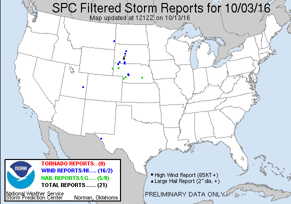
| Filtered Tornado Reports (CSV) (Raw Tornado CSV)(?) |
|---|
| No reports received |
| Filtered Hail Reports (CSV) (Raw Hail CSV)(?) |
|---|
Time | Size | Location | County | State | Lat | Lon | Comments |
| 1855 | 100 | TORRINGTON | GOSHEN | WY | 4207 | 10418 | (CYS) |
| 2105 | 150 | 7 N ALLIANCE | BOX BUTTE | NE | 4220 | 10287 | ALONG HIGHWAY 87. (CYS) |
| 2153 | 150 | 11 NNW IMPERIAL | CHASE | NE | 4066 | 10172 | (LBF) |
| 2243 | 100 | 1 N ELSIE | PERKINS | NE | 4086 | 10139 | PENNIES TO QUARTER SIZE HAIL COVERED THE GROUND. (LBF) |
| 0820 | 150 | AURORA | HAMILTON | NE | 4087 | 9800 | HAIL RANGED IN SIZE UP TO SIZE OF PING PONG BALLS. (GID) |
| Filtered Wind Reports (CSV) (Raw Wind CSV)(?) |
|---|
Time | Speed | Location | County | State | Lat | Lon | Comments |
| 1220 | 60 | 1 SSE BAKER | FALLON | MT | 4635 | 10426 | (BYZ) |
| 1302 | 59 | 17 NW MOAB | GRAND | UT | 3876 | 10975 | ASOS STATION CANYONLANDS FIELD AIRPORT /CNY/. (GJT) |
| 2042 | UNK | 14 NNE HERSHEY | LINCOLN | NE | 4135 | 10090 | CORRECTED TIME OF PREVIOUS DAMAGE REPORT. BARN BLOWN DOWN TRAPPING HORSES. SEVERAL LARGE LIMBS BLOWN DOWN. WINDS ESTIMATED TO BE 75MPH BASED ON DAMAGE. (LBF) |
| 2049 | 73 | CHADRON | DAWES | NE | 4283 | 10300 | (CYS) |
| 2136 | 60 | OGLALA | OGLALA LAKOTA | SD | 4318 | 10274 | PEA SIZE HAIL ALSO FELL (UNR) |
| 2235 | 61 | 1 SSE SIERRA BLANCA | HUDSPETH | TX | 3116 | 10535 | TTU WEST TEXAS MESONET (EPZ) |
| 2245 | 82 | INTERIOR | JACKSON | SD | 4373 | 10198 | (UNR) |
| 2300 | 77 | 4 E CACTUS FLAT | JACKSON | SD | 4384 | 10182 | (UNR) |
| 2308 | UNK | MERRIMAN | CHERRY | NE | 4292 | 10170 | TWO LARGE COTTONWOOD TREE BRANCHES SNAPPED OFF AT RESIDENTS. ONE TREE BRANCH MEASURED 8 INCHES IN DIAMETER ... WITH THE SECOND BEING 7 INCHES IN DIAMETER. TREES ARE HEAL (LBF) |
| 2314 | 60 | MARTIN | BENNETT | SD | 4317 | 10173 | (UNR) |
| 2315 | 70 | SE MERRIMAN | CHERRY | NE | 4292 | 10170 | ESTIMATED 65 TO 70 MPH WINDS. (LBF) |
| 2319 | 60 | 5 NE MILESVILLE | HAAKON | SD | 4452 | 10162 | (UNR) |
| 2322 | 60 | 4 N PHILIP | HAAKON | SD | 4410 | 10167 | (UNR) |
| 2341 | 60 | 14 SSE DUPREE | ZIEBACH | SD | 4486 | 10147 | (UNR) |
| 0045 | UNK | 14 NNE HERSHEY | LINCOLN | NE | 4135 | 10090 | CORRECTED TIME OF PREVIOUS REPORT. BARN COLLAPSED AND TRAPPED 2 HORSES. NUMEROUS LARGE TREE LIMBS DOWN. WIND SPEEDS ESTIMATED TO BE 75MPH. (LBF) |
| 0100 | UNK | 14 ENE HERSHEY | LINCOLN | NE | 4120 | 10075 | BARN COLLAPSE TRAPPED HORSES AND DOWNED SEVERAL LARGE TREE LIMBS DURING A THUNDERSTORM. WINDS ESTIMATED TO BE 75MPH (LBF) |
| Full report in comma-separated values (CSV) format and in KML format. |
| Full filtered report in comma-separated values (CSV) format and in KML format. |
| KML files are created with time-enabled placemarks compatible with Google Earth Time Slider. |
| Raw full report in comma-separated values (CSV) format |
| Fields marked UNK are unknown |
| All Times UTC |
| Wind Gusts in MPH |
| Hail Sizes in 1/100 of an Inch (175 = 1.75") |
| LAT/LON in decimal degrees to two decimals, see SPC FAQ for more info |
| List of Weather Forecast Office 3-letter IDs appear in the report comments section |
|
|
|
Top/Storm Reports/Home
|
|
|


 @NWSSPC