|
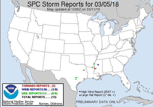
20180305's Storm Reports (20180305 1200 UTC - 20180306 1159 UTC) (Print Version)
|
< 180304 Reports
180306 Reports >
|
| Note: All Reports Are Considered Preliminary |
|
|
|
|
| Tornado Reports (CSV) (Raw Tornado CSV)(?) |
|---|
Time | | Location | County | State | Lat | Lon | Comments |
| 0005 | | 8 NW TALLULAH | MADISON | LA | 3250 | 9127 | VIDEO TAKEN FROM THE EAST SIDE OF BEAR LAKE OF A TORNADO ... SHARED VIA SOCIAL MEDIA. (JAN) |
| 0111 | | 10 NW EDWARDS | WARREN | MS | 3242 | 9073 | THIS WEAK TORNADO TOUCHED DOWN ALONG FOX ROAD WHERE A FEW TREES WERE UPROOTED AND LARGE BRANCHES SNAPPED. THE TORNADO TRAVELED FOR 2 MILES AND CROSSED FLOWERS HILL ROAD (JAN) |
| Hail Reports (CSV) (Raw Hail CSV)(?) |
|---|
Time | Size | Location | County | State | Lat | Lon | Comments |
| 2129 | 100 | 6 SE MUSTANG RIDGE | CALDWELL | TX | 3000 | 9761 | (EWX) |
| 2203 | 100 | 2 NW ROSANKY | BASTROP | TX | 2995 | 9731 | TIME ESTIMATED WITH RADAR. (EWX) |
| 2209 | 175 | DUCE | DESHA | AR | 3378 | 9127 | HAIL UP TO THE SIZE OF GOLF BALLS REPORTED AT GRANNYS STORE NEAR DUCE. (LZK) |
| 2209 | 150 | KELSO | DESHA | AR | 3380 | 9127 | (LZK) |
| 2251 | 100 | 2 ESE BASTROP | MOREHOUSE | LA | 3277 | 9188 | (JAN) |
| 2320 | 175 | BELMONT | GONZALES | TX | 2952 | 9768 | TWO PUBLIC REPORTS IN BELMONT OF HAIL RANGING FROM QUARTER TO GOLF BALL SIZED. TIME ESTIMATED WITH RADAR. (EWX) |
| 0017 | 100 | CARROLLTON | CARROLL | MS | 3351 | 8992 | (JAN) |
| 0032 | 100 | 2 W WINONA | MONTGOMERY | MS | 3349 | 8976 | MOSTLY SMALL HAIL ... BUT SOME UP TO QUARTER SIZE. (JAN) |
| Wind Reports (CSV) (Raw Wind CSV)(?) |
|---|
Time | Speed | Location | County | State | Lat | Lon | Comments |
| 1920 | UNK | 5 SW HENDERSON | RUSK | TX | 3211 | 9485 | SPOTTER REPORTED A DOWNED TREE AT US HWY. 79 AND AND CR 402 AS WELL AS AT CR. 407 AND 79. SPOTTER WITNESSED THE EVENT AND REPORTED WINDS NEAR 40 MPH. TREES WERE UPROOTE (SHV) |
| 0034 | UNK | 1 NW WINONA | MONTGOMERY | MS | 3350 | 8974 | AN 18 WHEELER WENT OFF A ROAD AND INTO A RAVINE ALONG US HIGHWAY 82 NEAR HIGHWAY 51. (JAN) |
| 0037 | UNK | 4 SSE WINONA | MONTGOMERY | MS | 3344 | 8970 | TREE WAS BLOWN DOWN NEAR THE INTERSECTION OF OLDHAM ROAD AND HIGHWAY 407. (JAN) |
|

| Filtered Tornado Reports (CSV) (Raw Tornado CSV)(?) |
|---|
Time | | Location | County | State | Lat | Lon | Comments |
| 0005 | | 8 NW TALLULAH | MADISON | LA | 3250 | 9127 | VIDEO TAKEN FROM THE EAST SIDE OF BEAR LAKE OF A TORNADO ... SHARED VIA SOCIAL MEDIA. (JAN) |
| 0111 | | 10 NW EDWARDS | WARREN | MS | 3242 | 9073 | THIS WEAK TORNADO TOUCHED DOWN ALONG FOX ROAD WHERE A FEW TREES WERE UPROOTED AND LARGE BRANCHES SNAPPED. THE TORNADO TRAVELED FOR 2 MILES AND CROSSED FLOWERS HILL ROAD (JAN) |
| Filtered Hail Reports (CSV) (Raw Hail CSV)(?) |
|---|
Time | Size | Location | County | State | Lat | Lon | Comments |
| 2129 | 100 | 6 SE MUSTANG RIDGE | CALDWELL | TX | 3000 | 9761 | (EWX) |
| 2203 | 100 | 2 NW ROSANKY | BASTROP | TX | 2995 | 9731 | TIME ESTIMATED WITH RADAR. (EWX) |
| 2209 | 175 | DUCE | DESHA | AR | 3378 | 9127 | HAIL UP TO THE SIZE OF GOLF BALLS REPORTED AT GRANNYS STORE NEAR DUCE. (LZK) |
| 2251 | 100 | 2 ESE BASTROP | MOREHOUSE | LA | 3277 | 9188 | (JAN) |
| 2320 | 175 | BELMONT | GONZALES | TX | 2952 | 9768 | TWO PUBLIC REPORTS IN BELMONT OF HAIL RANGING FROM QUARTER TO GOLF BALL SIZED. TIME ESTIMATED WITH RADAR. (EWX) |
| 0017 | 100 | CARROLLTON | CARROLL | MS | 3351 | 8992 | (JAN) |
| 0032 | 100 | 2 W WINONA | MONTGOMERY | MS | 3349 | 8976 | MOSTLY SMALL HAIL ... BUT SOME UP TO QUARTER SIZE. (JAN) |
| Filtered Wind Reports (CSV) (Raw Wind CSV)(?) |
|---|
Time | Speed | Location | County | State | Lat | Lon | Comments |
| 1920 | UNK | 5 SW HENDERSON | RUSK | TX | 3211 | 9485 | SPOTTER REPORTED A DOWNED TREE AT US HWY. 79 AND AND CR 402 AS WELL AS AT CR. 407 AND 79. SPOTTER WITNESSED THE EVENT AND REPORTED WINDS NEAR 40 MPH. TREES WERE UPROOTE (SHV) |
| 0034 | UNK | 1 NW WINONA | MONTGOMERY | MS | 3350 | 8974 | AN 18 WHEELER WENT OFF A ROAD AND INTO A RAVINE ALONG US HIGHWAY 82 NEAR HIGHWAY 51. (JAN) |
| The Storm Reports page is organized based on reports received from 1200 UTC to 1159 UTC the next day. For example, storm report page for 20150430 covers reports from 20150430 at 1200 UTC to 20150501 at 1159 UTC. |
| Full report in comma-separated values (CSV) format and in KML format. |
| Full filtered report in comma-separated values (CSV) format and in KML format. |
| KML files are created with time-enabled placemarks compatible with Google Earth Time Slider. |
| Raw full report in comma-separated values (CSV) format. |
| Fields marked UNK are unknown. |
| All Times UTC. |
| Wind Gusts in MPH. |
| Hail Sizes in 1/100 of an Inch (175 = 1.75") |
| LAT/LON in decimal degrees to two decimals, see SPC FAQ for more info. |
| List of Weather Forecast Office 3-letter IDs appear in the report comments section. |
|
|
|
Top/Storm Reports/Home
|
|
|


 @NWSSPC