Skip Navigation Links weather.gov 
NOAA logo-Select to go to the NOAA homepage NOAA's National Weather Service   Select to go to the NWS homepage
Storm Prediction Center
navigation bar left  
  navigation bar end cap


USA.gov is the U.S. Government's official Web portal to all Federal, state and local government Web resources and services.

Day 4-8 Severe Thunderstorm Outlook Issued on Apr-17-2005Day 4-8 Severe Weather Outlook Graphics Issued on Apr-17-2005

 Forecast Discussion

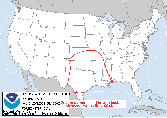
   DAY 4-8 CONVECTIVE OUTLOOK  
   NWS STORM PREDICTION CENTER NORMAN OK
   0320 AM CDT SUN APR 17 2005
   
   VALID 201200Z - 251200Z
   
   ...DISCUSSION...
   
   THE UPPER LOW OVER THE WRN STATES IS FORECAST TO FINALLY EJECT EWD
   THROUGH THE CNTRL PLAINS AND INTO THE MID MS VALLEY BY APRIL 22ND.
   WEAKER IMPULSES MAY ADVANCE EWD THROUGH THE PLAINS IN ADVANCE OF
   THIS FEATURE WITH SEVERAL EPISODES OF SEVERE WEATHER POSSIBLE. THE
   DRYLINE AND A SWD MOVING COLD FRONT WILL SERVE AS THE PRIMARY FOCI
   FOR SEVERE STORM DEVELOPMENT FROM THE CNTRL AND SRN PLAINS THROUGH
   THE LOWER MS VALLEY. THE BEST SEVERE WEATHER CHANCES ARE EXPECTED
   FROM APRIL 20TH TO APRIL 22ND.
   
   ..DIAL.. 04/17/2005

Weather Topics:
Watches, Mesoscale Discussions, Outlooks, Fire Weather, All Products, Contact Us

NOAA / National Weather Service
National Centers for Environmental Prediction
Storm Prediction Center
120 David L. Boren Blvd.
Norman, OK 73072 U.S.A.
spc.feedback@noaa.gov
Page last modified:
Disclaimer
Information Quality
Help
Glossary
Privacy Policy
Freedom of Information Act (FOIA)
About Us
Career Opportunities