|
Experimental Day 4-8 Severe Thunderstorm Outlook Issued on Nov 26, 2006
Updated: Sun Nov 26 08:05:05 UTC 2006
Note:
Comment Period: Oct 3, 2005 - July 28, 2006.
Please send your comments to spc.feedback@noaa.gov.
Product Definition Document (PDD) in HTML or MS-Word.
Note:
Increased variability in model forecasts with time and the
inability of the medium range models to resolve mesoscale features
results in greater uncertainty forecasting severe storms in the
Day 4-8 period.
SPC forecasters examine various deterministic and ensemble model
looking for synoptic patterns that favor at least a 25% or higher
probability for severe thunderstorms, before a severe weather area
is depicted.
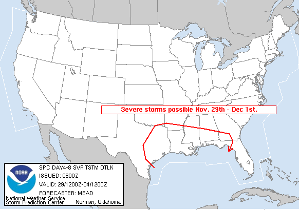
   DAY 4-8 CONVECTIVE OUTLOOK
   NWS STORM PREDICTION CENTER NORMAN OK
   0200 AM CST SUN NOV 26 2006

   VALID 291200Z - 041200Z

   ...DISCUSSION...

   VARYING MODEL SOLUTIONS CONTINUE TO EXIST WITH REGARD TO THE EWD
   MOVEMENT OF FULL LATITUDE TROUGH THE CNTRL AND ERN PARTS OF THE
   NATION.  THE GFS AND CMC ARE MOST PROGRESSIVE WITH THE ECMWF THE
   SLOWEST.  THE MEDIUM RANGE ENSEMBLE MEAN SOLUTION WAS USED AS A
   COMPROMISE.  AS SUCH...EXPECT WIND FIELDS TO INCREASE FROM THE SRN
   PLAINS EWD THROUGH THE GULF COAST STATES NOVEMBER 29TH THROUGH
   DECEMBER 1ST AS TROUGH SHIFTS EWD...GRADUALLY DEAMPLIFYING AS IT
   REACHES THE ATLANTIC COAST.

   IT APPEARS THAT THE BEST THREAT FOR A FEW SEVERE STORMS WILL EXIST
   FROM ERN TX WEDNESDAY NOVEMBER 29TH EWD ALONG THE GULF COAST THROUGH
   FRIDAY DECEMBER 1ST AS ATTENDANT...STRONG COLD FRONT ENCOUNTERS
   INCREASINGLY MOIST AIR MASS RETURNING FROM THE GULF OF MEXICO. WEAK
   LAPSE RATES WILL LIMIT THE DEGREE OF INSTABILITY...HOWEVER THE
   STRONG WIND FIELDS AND FORCING FOR ASCENT SHOULD BE SUPPORTIVE OF
   STORM ORGANIZATION.

   ..MEAD.. 11/26/2006
|
|


 @NWSSPC