|
Day 4-8 Convective Outlook Issued on Oct 26, 2009
Updated: Mon Oct 26 08:30:03 UTC 2009
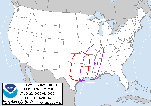
| D4 | Thu, Oct 29, 2009 - Fri, Oct 30, 2009 |
D7 | Sun, Nov 01, 2009 - Mon, Nov 02, 2009 |
| D5 | Fri, Oct 30, 2009 - Sat, Oct 31, 2009 |
D8 | Mon, Nov 02, 2009 - Tue, Nov 03, 2009 |
| D6 | Sat, Oct 31, 2009 - Sun, Nov 01, 2009 |
(All days are valid from 12 UTC - 12 UTC) |
Note: A severe weather
area depicted in the Day 4-8 period indicates a 30% or higher probability
for severe thunderstorms within 25 miles of any point.
PREDICTABILITY TOO LOW is used to indicate severe storms may be
possible based on some model scenarios.
However, the location or occurrence of severe storms are in doubt
due to: 1) large differences in the deterministic model solutions,
2) large spread in the ensemble guidance, and/or
3) minimal run-to-run continuity.
POTENTIAL TOO LOW means the threat for a regional area of
organized severe storms appears highly unlikely during the entire
period (e.g. less than a 30% probability for a regional severe
storm area across the CONUS through the entire Day 4-8 period).
   ZCZC SPCSWOD48 ALL
   ACUS48 KWNS 260829
   SPC AC 260829

   DAY 4-8 CONVECTIVE OUTLOOK
   NWS STORM PREDICTION CENTER NORMAN OK
   0329 AM CDT MON OCT 26 2009

   VALID 291200Z - 031200Z

   ...DISCUSSION...

   LATEST MEDIUM RANGE MODELS ARE IN GENERAL AGREEMENT REGARDING THE
   SPEED/MOVEMENT OF UPPER LOW EJECTING FROM THE CNTRL/SRN ROCKIES NEWD
   INTO THE GREAT LAKES/OH VALLEY REGION DURING THE DAY4-5 TIME FRAME.
   BOTH THE GFS AND ECMWF SUGGEST STRONG MID LEVEL FLOW WILL TRANSLATE
   THROUGH THE BASE OF THE TROUGH INTO THE MS VALLEY WHERE DEEPENING OF
   THIS LOW PRESSURE SYSTEM WILL BE NOTED THROUGH A DEEP LAYER.  WITH
   MOISTURE/INSTABILITY EXPECTED TO RETURN ACROSS THE SCNTRL
   U.S...THUNDERSTORMS SHOULD READILY DEVELOP ALONG ADVANCING COLD
   FRONT ACROSS OK/TX DAY4...THEN SHIFT EWD INTO THE MS VALLEY DAY5
   WHERE FRONTAL INTENSIFICATION IS EXPECTED.  IF SUFFICIENT
   INSTABILITY CAN RETURN TO IL/IND ORGANIZED SEVERE THUNDERSTORMS WILL
   LIKELY OCCUR AS INTENSE HEIGHT FALLS/FORCING WILL BE NOTED ACROSS
   THIS REGION.

   ..DARROW.. 10/26/2009

   CLICK TO GET WUUS48 PTSD48 PRODUCT
|
|


 @NWSSPC