|
| Day 4-8 Severe Weather Outlook Issued on Dec 16, 2012 |
| Updated: Sun Dec 16 17:50:03 UTC 2012 |
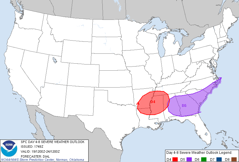 |
| D4 | Wed, Dec 19, 2012 - Thu, Dec 20, 2012 |
D7 | Sat, Dec 22, 2012 - Sun, Dec 23, 2012 |
| D5 | Thu, Dec 20, 2012 - Fri, Dec 21, 2012 |
D8 | Sun, Dec 23, 2012 - Mon, Dec 24, 2012 |
| D6 | Fri, Dec 21, 2012 - Sat, Dec 22, 2012 |
(All days are valid from 12 UTC - 12 UTC the following day) |
|
Note: A severe weather area depicted in the Day 4-8 period indicates a 30% or higher probability for severe thunderstorms within 25 miles of any point.
|
|
PREDICTABILITY TOO LOW is used to indicate severe storms may be possible based on some model scenarios. However, the location or occurrence of severe storms are in doubt due to: 1) large differences in the deterministic model solutions, 2) large spread in the ensemble guidance, and/or 3) minimal run-to-run continuity.
|
|
POTENTIAL TOO LOW means the threat for a regional area of organized severe storms appears highly unlikely during the entire period (e.g. less than a 30% probability for a regional severe storm area across the CONUS through the entire Day 4-8 period).
|
   ZCZC SPCSWOD48 ALL
   ACUS48 KWNS 161749
   SPC AC 161749

   DAY 4-8 CONVECTIVE OUTLOOK CORR 1
   NWS STORM PREDICTION CENTER NORMAN OK
   1149 AM CST SUN DEC 16 2012

   VALID 191200Z - 241200Z

   CORRECTED FOR DAYS OF WEEK

   ...DISCUSSION...
   DAY 4-5...MODELS HAVE CONVERGED ON AMPLITUDE AND TIMING OF A STRONG
   PROGRESSIVE SHORTWAVE TROUGH THAT WILL MOVE THROUGH THE SRN PLAINS
   DAY 4 /WEDNESDAY/...LOWER MS VALLEY WEDNESDAY NIGHT AND INTO THE OH
   VALLEY AND SERN STATES DAY 5 /THURSDAY/. THIS SYSTEM WILL INDUCE A
   STRONG SURFACE LOW THAT WILL MOVE FROM KS/OK WEDNESDAY INTO THE OH
   VALLEY THURSDAY. A COLD FRONT WILL SWEEP EWD THROUGH THE LOWER MS
   VALLEY AND SERN STATES IN ASSOCIATION WITH THIS FEATURE. PARTIALLY
   MODIFIED GULF AIR WILL ADVECT NWD ALONG A STRONG LLJ RESULTING IN
   DESTABILIZATION. HOWEVER...INSTABILITY WILL LIKELY REMAIN MARGINAL
   DUE TO EXPECTED WEAK LAPSE RATES. DESPITE THE LIMITED
   INSTABILITY...EXPECT A LINE OF FORCED CONVECTION TO DEVELOP
   WEDNESDAY NIGHT OVER THE LOWER MS VALLEY AND CONTINUE EWD THROUGH
   THE TN VALLEY AND SERN STATES DAY 5 /THURSDAY/. GIVEN THE STRENGTH
   OF THE NEAR-SFC AND DEEP-LAYER FLOW...DAMAGING WIND MAY BE A THREAT
   AS THE ACTIVITY DEVELOPS EWD.

   ..DIAL.. 12/16/2012

   CLICK TO GET WUUS48 PTSD48 PRODUCT
|
|


 @NWSSPC