Day 4-8 Severe Weather Outlook Issued on Mar 21, 2013
Updated: Thu Mar 21 08:12:02 UTC 2013
Risk
Area (sq. mi.)
Area Pop.
Some Larger Population Centers in Risk Area
No Risk Areas Forecast
D4
Sun, Mar 24, 2013 - Mon, Mar 25, 2013
D7
Wed, Mar 27, 2013 - Thu, Mar 28, 2013
D5
Mon, Mar 25, 2013 - Tue, Mar 26, 2013
D8
Thu, Mar 28, 2013 - Fri, Mar 29, 2013
D6
Tue, Mar 26, 2013 - Wed, Mar 27, 2013
(All days are valid from 12 UTC - 12 UTC the following day)
Note: A severe weather area depicted in the Day 4-8 period indicates a 30% or higher probability for severe thunderstorms within 25 miles of any point.
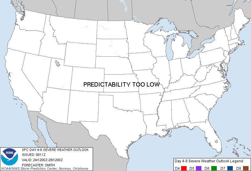
PREDICTABILITY TOO LOW is used to indicate severe storms may be possible based on some model scenarios. However, the location or occurrence of severe storms are in doubt due to: 1) large differences in the deterministic model solutions, 2) large spread in the ensemble guidance, and/or 3) minimal run-to-run continuity.
POTENTIAL TOO LOW means the threat for a regional area of organized severe storms appears highly unlikely during the entire period (e.g. less than a 30% probability for a regional severe storm area across the CONUS through the entire Day 4-8 period).
Forecast Discussion
   ZCZC SPCSWOD48 ALL
   ACUS48 KWNS 210811
   SPC AC 210811

   DAY 4-8 CONVECTIVE OUTLOOK
   NWS STORM PREDICTION CENTER NORMAN OK
   0311 AM CDT THU MAR 21 2013

   VALID 241200Z - 291200Z

   ...DISCUSSION...
   SEVERE POTENTIAL IN THE EXTENDED PERIOD WILL BE CONFINED TO SUNDAY
   /D4/ OVER PORTIONS OF THE SERN U.S. BEFORE A SURFACE CYCLONE MOVES
   OFFSHORE THE CAROLINA COAST AND A COLD FRONT SWEEPS THROUGH FL.
   ONGOING TSTMS OVER THIS REGION AND THE EFFECT OF
   CONVECTION-MODULATED BAROCLINIC BOUNDARIES PREVENTS MUCH CONFIDENCE
   IN THE QUALITY OF THE REMAINING WARM SECTOR THIS FAR IN ADVANCE.
   THUS...A 30 PERCENT PROBABILITY AREA IS NOT WARRANTED ATTM.

   BY EARLY NEXT WEEK...A MUCH COOLER/STABLE AIRMASS OF CONTINENTAL
   ORIGIN WILL ENCOMPASS THE CONUS.  NO SEVERE POTENTIAL IS EXPECTED
   OVER THE ENTIRE CONUS FROM MONDAY /DAY 5/ THROUGH LATE NEXT WEEK.

   ..SMITH.. 03/21/2013

   CLICK TO GET WUUS48 PTSD48 PRODUCT


 @NWSSPC