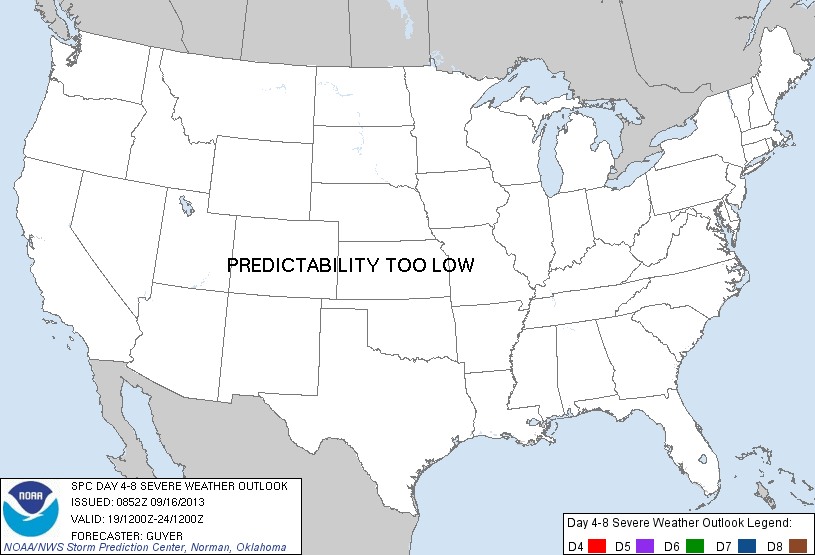
Day 4-8 Severe Weather Outlook Issued on Sep 16, 2013
Updated: Mon Sep 16 08:54:03 UTC 2013
Risk
Area (sq. mi.)
Area Pop.
Some Larger Population Centers in Risk Area
No Risk Areas Forecast
D4
Thu, Sep 19, 2013 - Fri, Sep 20, 2013
D7
Sun, Sep 22, 2013 - Mon, Sep 23, 2013
D5
Fri, Sep 20, 2013 - Sat, Sep 21, 2013
D8
Mon, Sep 23, 2013 - Tue, Sep 24, 2013
D6
Sat, Sep 21, 2013 - Sun, Sep 22, 2013
(All days are valid from 12 UTC - 12 UTC the following day)
Note: A severe weather area depicted in the Day 4-8 period indicates a 30% or higher probability for severe thunderstorms within 25 miles of any point.
PREDICTABILITY TOO LOW is used to indicate severe storms may be possible based on some model scenarios. However, the location or occurrence of severe storms are in doubt due to: 1) large differences in the deterministic model solutions, 2) large spread in the ensemble guidance, and/or 3) minimal run-to-run continuity.
POTENTIAL TOO LOW means the threat for a regional area of organized severe storms appears highly unlikely during the entire period (e.g. less than a 30% probability for a regional severe storm area across the CONUS through the entire Day 4-8 period).
Forecast Discussion
   ZCZC SPCSWOD48 ALL
   ACUS48 KWNS 160852
   SPC AC 160852

   DAY 4-8 CONVECTIVE OUTLOOK
   NWS STORM PREDICTION CENTER NORMAN OK
   0352 AM CDT MON SEP 16 2013

   VALID 191200Z - 241200Z

   ...DISCUSSION...
   00Z DETERMINISTIC/ENSEMBLE GUIDANCE INDICATE A PROGRESSIVE BELT OF
   WESTERLIES WILL CONTINUE OVER THE NORTHERN HALF OF THE CONUS AND
   CANADA THROUGH THE WEEK. THIS WILL BE HIGHLIGHTED BY THE EASTWARD
   PROGRESSION OF AN UPPER TROUGH OVER THE NORTH-CENTRAL CONUS/GREAT
   LAKES AND CENTRAL CANADA THROUGH DAYS 4-5 THURSDAY/FRIDAY. LOW-LEVEL
   MOISTURE WILL SPREAD NORTHEASTWARD INTO MUCH OF THE MIDDLE/UPPER MS
   RIVER VALLEY...MIDWEST...AND EVENTUALLY PORTIONS OF THE NORTHEAST
   STATES AHEAD OF A SOUTHEASTWARD-MOVING COLD FRONT ON DAYS 4-5. WHILE
   THE EXPECTED MAGNITUDE DOES NOT WARRANT A 30 PERCENT EQUIVALENT RISK
   AREA /MODEST VERTICAL SHEAR/...IT APPEARS THAT SOME SEVERE TSTMS
   WILL BE POSSIBLE ON DAY 4/THURSDAY ACROSS THE UPPER MIDWEST AND
   UPPER/MIDDLE MS RIVER VALLEY ALONG/AHEAD OF THE COLD FRONT. AS THE
   FRONT CONTINUES SOUTHEASTWARD...A SIMILAR SEVERE RISK COULD
   POTENTIALLY SPREAD INTO ADDITIONAL PARTS OF THE GREAT LAKES/OH RIVER
   VALLEY ON DAY 5/FRIDAY.

   INTO THIS WEEKEND...A SECONDARY UPPER TROUGH IS EXPECTED TO
   OVERSPREAD THE WESTERN STATES/ROCKIES BY DAYS 6-7 SATURDAY/SUNDAY.
   EARLY INDICATIONS ARE THAT AT LEAST SOME SEVERE TSTMS WILL BE
   POSSIBLE LATE THIS WEEKEND/EARLY NEXT WEEK...PERHAPS INITIALLY
   ACROSS THE NORTH-CENTRAL HIGH PLAINS ON DAY 7/SUNDAY.

   ..GUYER.. 09/16/2013

   CLICK TO GET WUUS48 PTSD48 PRODUCT


 @NWSSPC