Storm Prediction Center Day 1 Fire Weather Outlook
Created: Tue Feb 28 08:04:02 UTC 2017 (
![]() |
| ![]() )
)
|
Click for Day 1 FireWX Areal Outline Product
ZCZC SPCFWDDY1 ALL
FNUS21 KWNS 280758
Day 1 Fire Weather Outlook
NWS Storm Prediction Center Norman OK
0158 AM CST Tue Feb 28 2017
Valid 281200Z - 011200Z
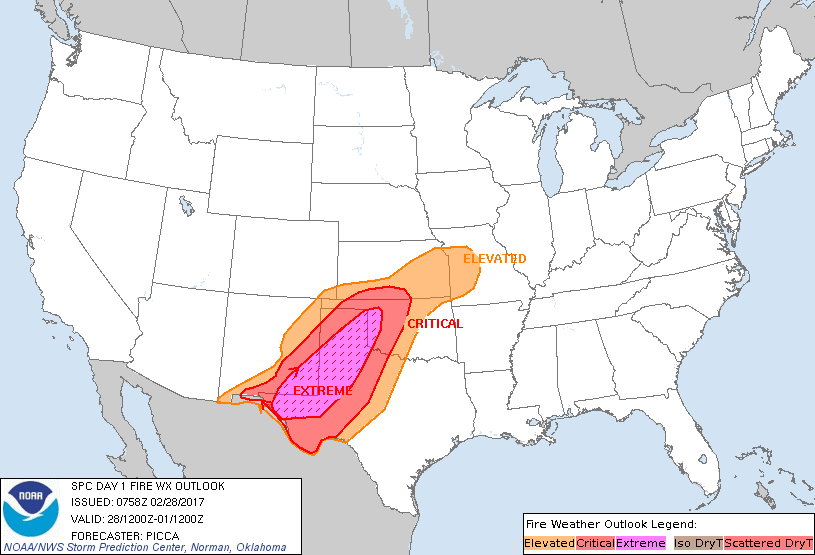
...EXTREMELY CRITICAL FIRE WEATHER AREA FOR PORTIONS OF SOUTHEAST
NEW MEXICO...FAR WEST TEXAS...THE SOUTHEAST TEXAS PANHANDLE...AND
FAR WESTERN OKLAHOMA...
...CRITICAL FIRE WEATHER AREA FOR PORTIONS OF THE SOUTHERN PLAINS
SURROUNDING THE EXTREMELY CRITICAL AREA...
...Synopsis...
As a mid-level shortwave trough rapidly transits eastward across the
Desert Southwest, a strong southwesterly jet maximum will develop
from northern Mexico northeastward to the mid Mississippi Valley. In
response, a surface cold front will advance southeastward across the
Plains states through the period. Along this front, one cyclone will
rapidly transit northeastward into the Great Lakes region, while
another will deepen slightly as it progresses east across far
northern Oklahoma.
...Dangerous fire-weather conditions to develop across parts of the
southern Plains today...
With a 60-70 kt 700-mb jet core positioned from southern New Mexico
to northern Oklahoma by mid-day, deep diurnal mixing will encourage
very strong winds across much of the region. A corridor of 30-45 mph
sustained southwesterly winds is expected to materialize across
eastern NM, western TX, the TX Panhandle, and far western OK by
afternoon. Additionally, gusts of 55-65 mph will be possible in this
corridor. 00Z AMA/MAF soundings depict a very dry tropospheric
profile already established, such that the onset of deep mixing and
strong downslope flow later today will lead to RH values falling to
around 8-13 percent. In tandem with dry fuels, these meteorological
conditions will create extremely critical concerns, characterized by
very rapid and erratic fire spread behavior.
Surrounding the extremely critical area, critical concerns are
anticipated from portions of southern NM northeastward to
south-central Kansas. Within this area, strong westerly winds near
30-45 mph sustained and RH values around 15-20 percent will enhance
the fire spread potential across southern/eastern NM into the OK
panhandle. Across the TX Rolling Plains, west-central OK, and
southern KS, southwesterly winds around 20-30 mph and RH values near
12-25 percent can be expected.
While RH values will begin to increase with the late afternoon /
evening passage of a cold front across southwest Kansas, the TX/OK
panhandles, and northwest OK, the rapid shift of wind direction to
the north will complicate ongoing firefighting efforts.
...Portions of eastern Kansas into Missouri...
The elevated area is also expanded northeastward to include eastern
Kansas and west-central Missouri. Recent guidance suggests dry air
should overspread the area today, such that diurnal mixing results
in RH values near 20-35 percent. Stout southwesterly winds near
20-30 mph and dry fuels will combine with dry conditions to produce
elevated/locally critical concerns.
..Picca.. 02/28/2017
...Please see www.spc.noaa.gov/fire for graphic product...