Storm Prediction Center Day 1 Fire Weather Outlook
Created: Thu Sep 14 05:19:02 UTC 2017 (
![]() |
| ![]() )
)
| |||||||||
Click for Day 1 FireWX Areal Outline Product
ZCZC SPCFWDDY1 ALL
FNUS21 KWNS 140516
Day 1 Fire Weather Outlook
NWS Storm Prediction Center Norman OK
1216 AM CDT Thu Sep 14 2017
Valid 141200Z - 151200Z
...Synopsis...
In the mid levels, the flow over the central Rockies vicinity will
attain more of a zonal component today. As a result, surface lee
troughing will occur over the central High Plains, south of a
frontal zone extending from the upper Mississippi Valley to the
northern Plains. This will contribute to a tightened pressure
gradient over portions of the central states.
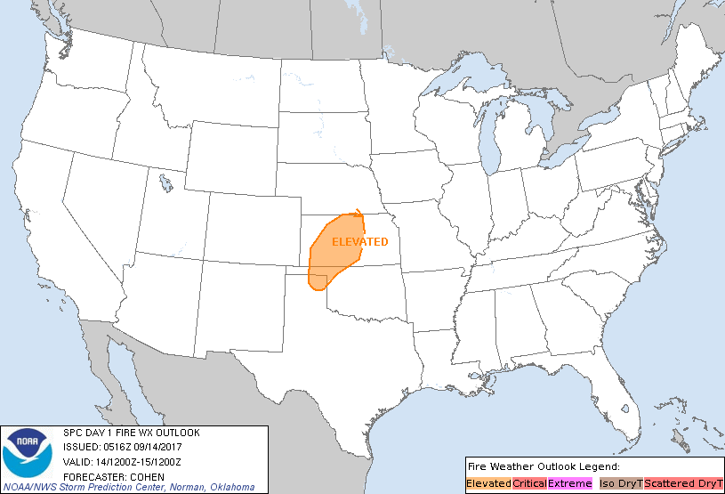
...Portions of KS, the OK/TX Panhandles, northwest OK...
The aforementioned tightened pressure gradient is expected to
support southerly to south-southwesterly surface winds of 15-22 mph
with higher gusts. Moisture return will be very limited, owing to
the antecedent reinforcement of dry air over the south-central
states (south of the remnants of Tropical Cyclone Irma). As
temperatures warm into the lower to middle 90s, RH should fall to
19-24 percent (lowest readings in western KS and the OK/TX
Panhandles). Given the drying of fine fuels related to the lack of
recent precipitation, elevated fire-weather conditions are
anticipated. However, given the lack of an even drier air mass, RH
is not expected to become sufficiently low amidst strong winds for
Critical designation.
...Southern Idaho...
Locally elevated fire-weather conditions may occur across the area,
including the Snake River Valley, as 10-15 mph surface winds combine
with RH falling to the 20s. The anticipated marginal/spotty nature
of any elevated fire-weather risk preclude highlights. Furthermore,
wetting rainfall has contributed to unfavorable fuels for fire
spread in some areas.
..Cohen.. 09/14/2017
...Please see www.spc.noaa.gov/fire for graphic product...