Storm Prediction Center Day 1 Fire Weather Outlook
Created: Sun Mar 4 07:29:02 UTC 2018 (
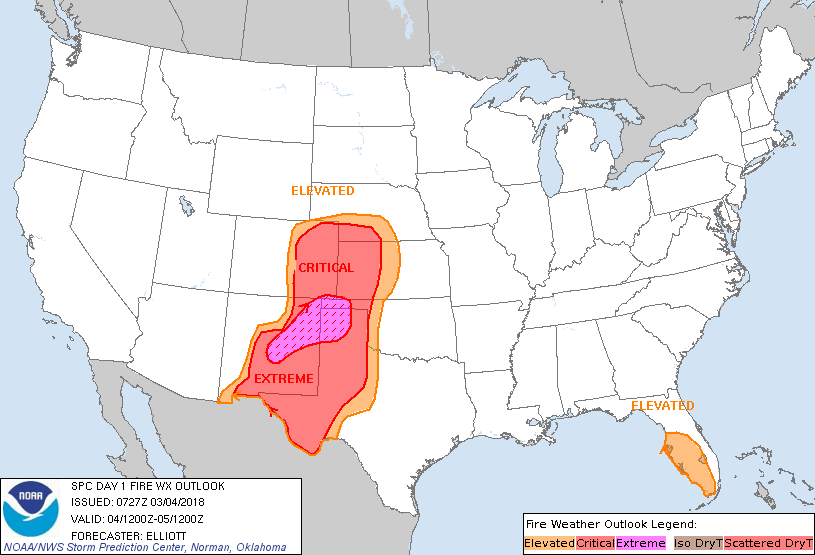
![]() |
| ![]() )
)
|
Click for Day 1 FireWX Areal Outline Product
   ZCZC SPCFWDDY1 ALL
   FNUS21 KWNS 040727

   Day 1 Fire Weather Outlook
   NWS Storm Prediction Center Norman OK
   0127 AM CST Sun Mar 04 2018

   Valid 041200Z - 051200Z

   ...EXTREMELY CRITICAL FIRE WEATHER AREA FOR PARTS OF EASTERN NEW
   MEXICO...THE TEXAS/OKLAHOMA PANHANDLES...AND FAR SOUTHEASTERN
   COLORADO...
   ...CRITICAL FIRE WEATHER AREA FOR PORTIONS OF THE SOUTHERN AND
   CENTRAL HIGH PLAINS...

   ...Synopsis...
   A compact belt of 80-90 knot mid-level winds -- near the base of a
   large-scale western U.S. trough -- will move eastward over the four
   corners region and emerge over the plains through tonight. As this
   occurs, a lee cyclone over eastern Colorado is expected to rapidly
   deepen to ~996 mb while shifting toward western Kansas/Nebraska by
   evening. An associated dryline will extend southward from the
   surface cyclone -- initially being located along a N/S line near the
   Colorado/Kansas and Texas/New Mexico borders this morning before
   surging eastward into western Nebraska, western Kansas, most of the
   Oklahoma/Texas Panhandles, and western portions of the Edwards
   Plateau into this evening. A cold front is then forecast to shift
   across much of the central and southern High Plains tonight.

   ...Dangerous fire-weather conditions expected across parts of the
   central and southern Plains...
   A large area of high-end Critical fire weather conditions are
   expected today as strong low-level winds interact with an
   antecedently dry air mass and fuels that remain very dry from recent
   drought conditions.

   Downslope low-level westerly flow is forecast to strengthen today as
   the surface pressure gradient associated with the aforementioned lee
   cyclone tightens and efficient deep-layer mixing transfers
   higher-momentum air from aloft (from the approaching speed maxima)
   to the surface. Poor overnight RH recoveries, resulting from a very
   dry air mass, suggest that Critical fire weather conditions may
   already be ongoing to the west of the dryline this morning. Fire
   weather conditions are then expected to intensify while spreading
   eastward with the dryline surge through the day. The precise eastern
   edge of the Critical fire weather area is somewhat uncertain, as it
   will be modulated by how far east the dryline progresses --
   something which model guidance often struggles with. Critical to
   high-end Critical conditions are expected west of the dryline, with
   sustained wind speeds of 20-30 mph (higher gusts), RH values of
   5-15%, and very dry fuels.

   An Extremely Critical fire weather area has been maintained across
   portions of northeast New Mexico, far southeastern Colorado, and far
   southwestern Kansas where RH values of less than 10%, sustained wind
   speeds in excess of 30 mph (with gusts in excess of 50 mph), the
   center of the thermal ridge, and ERC values into the 90th percentile
   intersect. The Extremely Critical fire weather area was expanded
   slightly farther southwest into central New Mexico based on the
   latest high-resolution guidance.

   A pacific cold front is expected to cross through the area from west
   to east overnight. While cooler temperatures are expected in its
   wake, the air mass behind it will be extremely dry and may allow
   Elevated/Critical conditions to persist into the overnight as
   sustained winds remain 20+ mph behind the front (especially across
   eastern Colorado, western Nebraska/Kansas, and the Oklahoma/Texas
   Panhandles). Additionally, the abrupt wind shift -- to northwesterly
   -- associated with front will likely exacerbate any ongoing fire
   fighting efforts.

   ...Portions of Florida...
   00Z soundings at TBW/TLH depict a very dry air mass across much of
   Florida -- except near the Atlantic Coast. This air mass is expected
   to remain in place today, as post-frontal northeasterly flow
   persists. While critical RH values (i.e., less than 35%) are
   expected across the area and fuels are relatively dry, sustained
   surface winds are forecast to remain around 10-15 mph, which
   supports Elevated fire weather conditions. A Critical fire weather
   area could be needed in a future update if trends in guidance
   suggest sustained winds speeds will be stronger than currently
   forecast.

   ...Portions of Georgia and South Carolina...
   While a dry air mass -- with critically-lowered RH values -- is
   forecast over the area, the lack of stronger low-level flow (e.g.,
   sustained surface winds are forecast to generally remain less than
   10 mph) precludes introduction of an Elevated area. However, locally
   Elevated fire weather conditions are possible where wind speeds are
   enhanced and fuels receptive.

   ..Elliott.. 03/04/2018

   ...Please see www.spc.noaa.gov/fire for graphic product...