Skip Navigation Links weather.gov 
NOAA logo-Select to go to the NOAA homepage NOAA's National Weather Service   Select to go to the NWS homepage
Storm Prediction Center
navigation bar left  
  navigation bar end cap


USA.gov is the U.S. Government's official Web portal to all Federal, state and local government Web resources and services.

Mesoscale Discussion 419
< Previous MD          Next MD >
MD 419 graphic
   
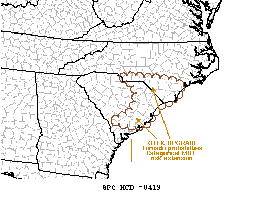
   MESOSCALE DISCUSSION 0419
   NWS STORM PREDICTION CENTER NORMAN OK
   1030 AM CDT SAT MAR 15 2008
   
   AREAS AFFECTED...SC COASTAL PLAIN...PORTIONS S-CENTRAL AND SERN NC.
   
   CONCERNING...OUTLOOK UPGRADE 
   
   VALID 151530Z - 151630Z
   
   INCREASING PROBABILITIES OF TORNADOES FOR LATE AFTERNOON/EARLY
   EVENING -- REPRESENTING EWD SHIFT OF THREAT INDICATED EARLIER ACROSS
   GA/SC -- WILL DRIVE CATEGORICAL SPC DAY-1 OUTLOOK UPGRADE TO MDT
   RISK EWD TO COAST.  REF UPCOMING 1630Z FCST FOR MORE DETAILS.
   
   ..EDWARDS.. 03/15/2008
   
   
   ATTN...WFO...MHX...RAH...ILM...CHS...CAE...GSP...
   
   33068133 33428039 34378004 34828049 35078089 34947860
   34797792 34587748 34467743 34247778 33847796 33917809
   33857853 33467908 33147920 32877963 32777993 
   
Top/All Mesoscale Discussions/Forecast Products/Home
Weather Topics:
Watches, Mesoscale Discussions, Outlooks, Fire Weather, All Products, Contact Us

NOAA / National Weather Service
National Centers for Environmental Prediction
Storm Prediction Center
120 David L. Boren Blvd.
Norman, OK 73072 U.S.A.
spc.feedback@noaa.gov
Page last modified: January 01, 1970
Disclaimer
Information Quality
Help
Glossary
Privacy Policy
Freedom of Information Act (FOIA)
About Us
Career Opportunities