|
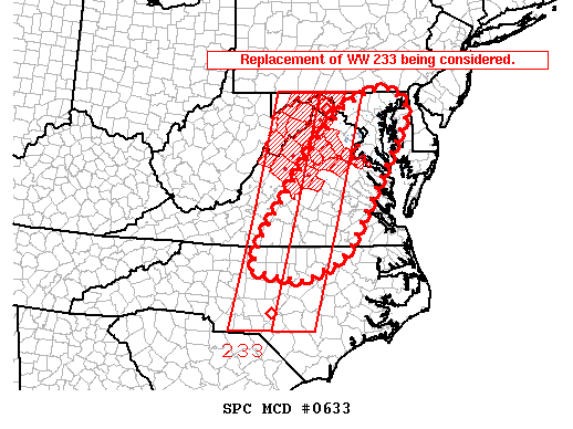
| Mesoscale Discussion 633 |
|
< Previous MD Next MD >
|
|
   MESOSCALE DISCUSSION 0633
   NWS STORM PREDICTION CENTER NORMAN OK
   0500 PM CDT WED APR 27 2011

   AREAS AFFECTED...PORTIONS OF THE MID-ATLANTIC

   CONCERNING...TORNADO WATCH 233...

   VALID 272200Z - 272300Z

   THE SEVERE WEATHER THREAT FOR TORNADO WATCH 233 CONTINUES.

   A REPLACEMENT OF WW 233 IS BEING CONSIDERED FOR THE PIEDMONT OF
   N-CNTRL NC THROUGH CNTRL MD. TSTM COVERAGE HAS INCREASED TO THE SW
   OF WW 233 AMIDST A SUPERCELL ENVIRONMENT CHARACTERIZED BY MLCAPE OF
   1000 TO 2000 J/KG AND EFFECTIVE SHEAR AROUND 35 TO 45 KT. WITH THE
   LOW-LEVEL WIND PROFILE FORECAST TO STRENGTHEN THROUGH THE
   EVENING...TSTMS SHOULD REMAIN CAPABLE OF ALL SEVERE THREATS BEYOND
   00Z...POTENTIALLY NECESSITATING A REPLACEMENT WW.

   ..GRAMS.. 04/27/2011


   ATTN...WFO...PHI...AKQ...CTP...LWX...RAH...RNK...

   LAT...LON   36227782 35877858 36077989 36677970 38787823 39407753
               39747691 39787621 39487591 39217588 38187645 36547743
               36227782
|
|
Top/All Mesoscale Discussions/Forecast Products/Home
|
|


 @NWSSPC