Skip Navigation Links weather.gov 
NOAA logo-Select to go to the NOAA homepage NOAA's National Weather Service   Select to go to the NWS homepage
Storm Prediction Center
navigation bar left  
  navigation bar end cap


USA.gov is the U.S. Government's official Web portal to all Federal, state and local government Web resources and services.

Mesoscale Discussion 2120
< Previous MD         Next MD >
MD 2120 graphic
   
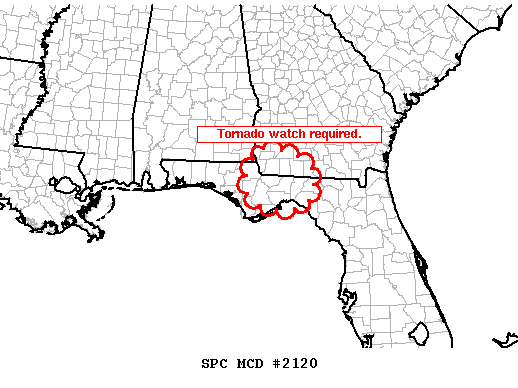
   MESOSCALE DISCUSSION 2120
   NWS STORM PREDICTION CENTER NORMAN OK
   1127 AM CDT SUN SEP 04 2011
   
   AREAS AFFECTED...REMAINDER OF FL PNHDL INTO SWRN GA
   
   CONCERNING...SEVERE POTENTIAL...WATCH NEEDED SOON 
   
   VALID 041627Z - 041700Z
   
   RECENT OBSERVATIONAL DATA INDICATE THAT AIR MASS DESTABILIZATION IS
   OCCURRING ALONG ERN ENVELOPE OF STRONGER LOW-LEVEL WIND FIELD
   ASSOCIATED WITH T.S. LEE.  THE RESULT IS ORGANIZING STORM STRUCTURES
   INVOF TLH WHICH WILL HAVE THE POTENTIAL TO EVOLVE INTO SUPERCELLS
   WITH AN ASSOCIATED TORNADO THREAT.
   
   ..MEAD.. 09/04/2011
   
   
   ATTN...WFO...TAE...
   
   LAT...LON   30678527 31328500 31248408 30798341 30288346 29958371
               29868473 30218523 30678527 
   
Top/All Mesoscale Discussions/Forecast Products/Home
Weather Topics:
Watches, Mesoscale Discussions, Outlooks, Fire Weather, All Products, Contact Us

NOAA / National Weather Service
National Centers for Environmental Prediction
Storm Prediction Center
120 David L. Boren Blvd.
Norman, OK 73072 U.S.A.
spc.feedback@noaa.gov
Page last modified: January 01, 1970
Disclaimer
Information Quality
Help
Glossary
Privacy Policy
Freedom of Information Act (FOIA)
About Us
Career Opportunities