|
| Mesoscale Discussion 715 |
|
< Previous MD Next MD >
|
|
MESOSCALE DISCUSSION 0715
NWS STORM PREDICTION CENTER NORMAN OK
0356 PM CDT THU MAY 21 2015
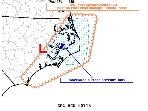
AREAS AFFECTED...ERN NC AND OUTER BANKS
CONCERNING...SEVERE THUNDERSTORM WATCH 193...
VALID 212056Z - 212200Z
THE SEVERE WEATHER THREAT FOR SEVERE THUNDERSTORM WATCH 193
CONTINUES.
SUMMARY...LOW-LEVEL MESOCYCLONES WILL POSE AN ISOLD WIND
DAMAGE/TORNADO THREAT OVER THE NEXT HOUR OR SO.
DISCUSSION...SURFACE ANALYSIS SHOWS AN AREA OF MAXIMIZED PRESSURE
FALLS /AOB 3 MB PER 2 HOURS/ OVER FAR NERN NC IMMEDIATELY AHEAD OF A
1006 MB SURFACE LOW. A BROKEN SQUALL LINE WITH SEMI-DISCRETE
SUPERCELLS WITH ACCOMPANYING CYCLIC MESOCYCLONES WILL POSE A WIND
DAMAGE RISK AS THE CONVECTIVE BAND CONTINUES EWD. RICH LOW-LEVEL
MOISTURE CHARACTERIZED BY DEWPOINTS IN THE 70-72 RANGE NEAR THE
COAST COUPLED WITH 200 M2/S2 0-1 KM SRH WILL SUPPORT SOME RISK FOR
AN ISOLD TORNADO BEFORE THE CONVECTIVE BAND MOVES OFF THE COAST
LATER THIS AFTERNOON.
..SMITH.. 05/21/2015
ATTN...WFO...AKQ...MHX...ILM...
LAT...LON 36687601 35337712 34147825 33817758 34887510 36687465
36687601
|
|
Top/All Mesoscale Discussions/Forecast Products/Home
|
|


 @NWSSPC