|
| Mesoscale Discussion 759 |
|
< Previous MD Next MD >
|
|
Mesoscale Discussion 0759
NWS Storm Prediction Center Norman OK
0216 PM CDT Thu May 18 2017
Areas affected...Portions of eastern KS and western MO
Concerning...Severe potential...Tornado Watch likely
Valid 181916Z - 182115Z
Probability of Watch Issuance...80 percent
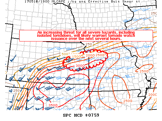
SUMMARY...An increasing threat for all severe hazards, including
isolated tornadoes, will likely warrant tornado watch issuance over
the next several hours.
DISCUSSION...Satellite trends show building cumulus along a warm
front extending across KS into western MO as of 1915Z. The airmass
along and south of the front is strongly unstable, with MLCAPE in
the 2000-3500 J/kg range. As a 50+ kt southwesterly mid-level jet
approaches this region, large-scale forcing for ascent will
gradually increase. Low-level convergence along the front in tandem
with the increasing large-scale ascent should be sufficient for
convective initiation over the next several hours. Recent short-term
model guidance is generally consistent in developing convection
along the warm front by 21Z. Strengthening mid-level winds will
support effective bulk shear values of 40-50 kt, and supercells
structures appear likely.
Although low-level flow is not forecast to be quite as strong as
locations farther west (mainly western/central KS), backed
easterly/northeasterly winds in the 0-1 km layer along the front
will enhance effective SRH through the afternoon and early evening,
and isolated tornadoes will be possible. Low-level winds are
forecast to increase across this region by this evening as a
low-level jet strengthens across the central/southern Plains. If
initially discrete supercells remain the dominant storm mode into
this evening, then the tornado threat would increase in the 00-03Z
time frame. In addition to the isolated tornado threat, the very
favorable thermodynamic environment and steep mid-level lapse rates
present across this region will likely support large to very large
hail with any supercell. Isolated damaging winds may also occur.
..Gleason/Goss.. 05/18/2017
...Please see www.spc.noaa.gov for graphic product...
ATTN...WFO...EAX...TOP...ICT...
LAT...LON 38209640 38479707 38879647 39159556 39419420 39299335
39059292 38719326 38379414 38019602 38209640
|
|
Top/All Mesoscale Discussions/Forecast Products/Home
|
|


 @NWSSPC