|
| Mesoscale Discussion 1801 |
|
< Previous MD Next MD >
|
|
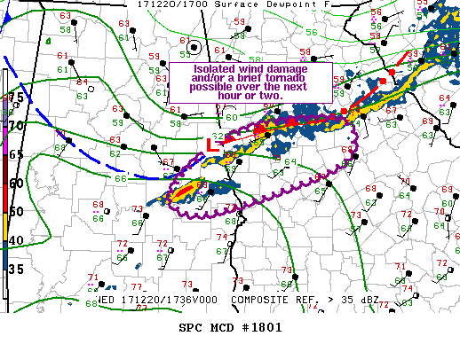
   Mesoscale Discussion 1801
   NWS Storm Prediction Center Norman OK
   1146 AM CST Wed Dec 20 2017

   Areas affected...Far east-central AL...West-central GA

   Concerning...Severe potential...Watch unlikely

   Valid 201746Z - 201945Z

   Probability of Watch Issuance...20 percent

   SUMMARY...Isolated wind damage and/or a brief tornado is possible
   over the next hour or two across far east-central AL and
   west-central GA. Watch not currently anticipated.

   DISCUSSION...Current surface analysis suggests a weak surface low
   exists across far east-central AL (approximately 25 mi northwest of
   LGC) with a warm front extending eastward/east-northeastward across
   northern GA. Storms within close proximity to this low and warm
   front (i.e Troup and Coweta) have shown some low-level rotation over
   the past 15-30 minutes, likely a result of the slightly better
   mesoscale forcing for ascent and storm interactions with the warm
   front. As such, isolated instances of wind damage and a brief
   tornado are possible. However, weak instability should moderate
   updraft strength and limit persistence, tempering the overall severe
   potential. Current expectation is for the limited severe threat to
   preclude the need for a watch, but convective trends will be
   monitored closely.

   ..Mosier/Guyer.. 12/20/2017

   ...Please see www.spc.noaa.gov for graphic product...

   ATTN...WFO...FFC...BMX...

   LAT...LON   32618601 33038561 33438476 33498346 33128329 32828378
               32358542 32428596 32618601
|
|
Top/All Mesoscale Discussions/Forecast Products/Home
|
|


 @NWSSPC