|
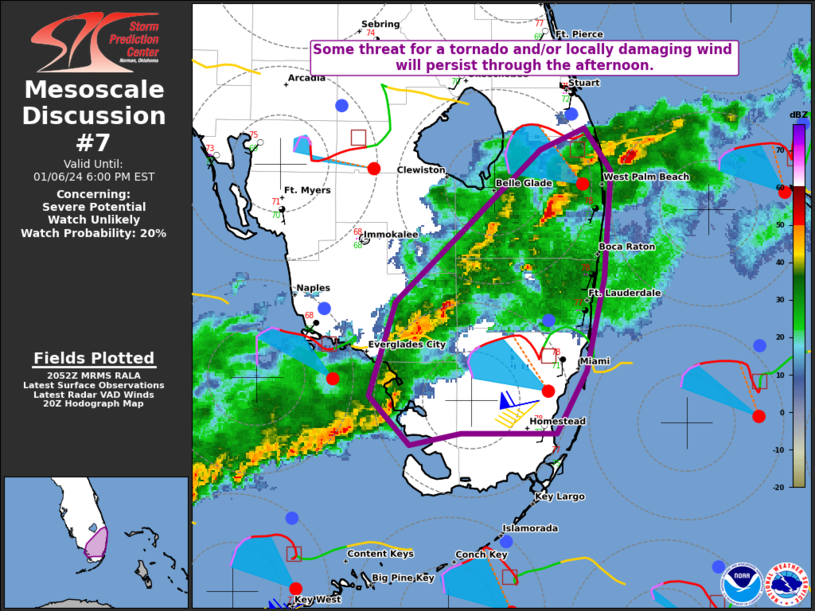
| Mesoscale Discussion 7 |
|
< Previous MD Next MD >
|
|
   Mesoscale Discussion 0007
   NWS Storm Prediction Center Norman OK
   0254 PM CST Sat Jan 06 2024

   Areas affected...Parts of south FL

   Concerning...Severe potential...Watch unlikely

   Valid 062054Z - 062300Z

   Probability of Watch Issuance...20 percent

   SUMMARY...Some threat for a tornado and/or locally damaging wind
   will persist through the remainder of the afternoon.

   DISCUSSION...Occasional low/midlevel rotation has been noted with
   storms moving across south FL this afternoon, most recently to the
   southwest of Palm Beach. Widespread cloudiness and weak midlevel
   lapse rates (as noted on the 18Z KEY sounding) continue to limit
   instability across the region, though rich moisture (with low 70s F
   dewpoints) is supporting MLCAPE of 500-1000 J/kg, sufficient to
   sustain organized convection within a favorably sheared environment.

   While low-level flow is expected to gradually weaken and veer with
   time, 0-1 km SRH still in the 150-250 m2/s2 range (as noted in
   recent objective mesoanalyses and the KAMX VWP) will support the
   potential for a tornado or two across south FL through the remainder
   of the afternoon, if any supercells can be sustained. Some potential
   for locally damaging wind may also develop, especially where
   somewhat stronger heating has been noted this afternoon. With the
   threat expected to remain rather isolated and limited in areal
   extent, watch issuance is considered unlikely.

   ..Dean/Hart.. 01/06/2024

   ...Please see www.spc.noaa.gov for graphic product...

   ATTN...WFO...MFL...MLB...

   LAT...LON   25628137 26108122 26888039 26998015 26777999 26238003
               25758014 25448030 25448085 25388113 25628137
|
|
Top/All Mesoscale Discussions/Forecast Products/Home
|
|


 @NWSSPC