|
| Mesoscale Discussion 31 |
|
< Previous MD Next MD >
|
|
Mesoscale Discussion 0031
NWS Storm Prediction Center Norman OK
1142 AM CST Tue Jan 09 2024
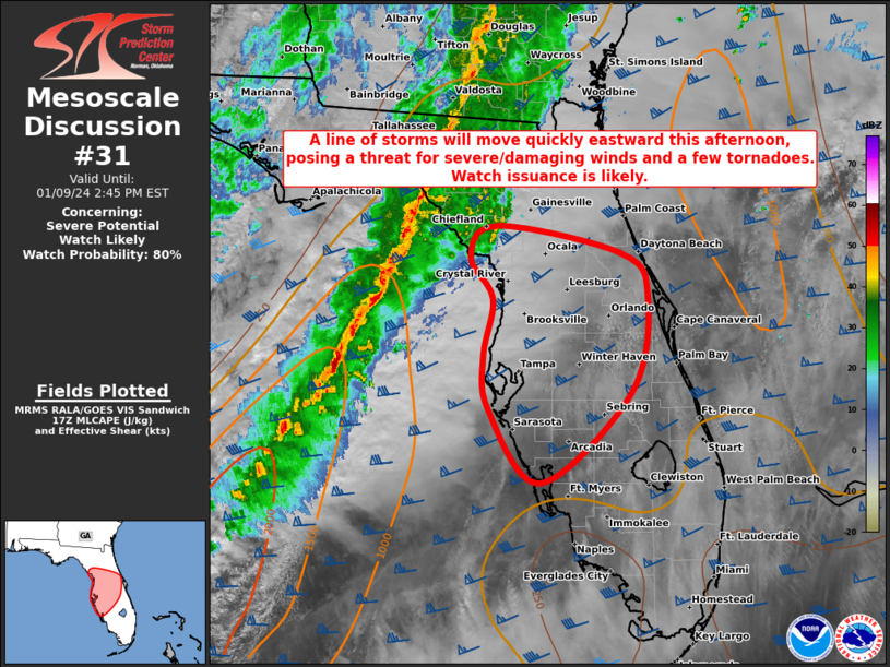
Areas affected...Portions of the northern and central FL Peninsula
Concerning...Severe potential...Watch likely
Valid 091742Z - 091945Z
Probability of Watch Issuance...80 percent
SUMMARY...A line of thunderstorms will move quickly eastward this
afternoon, posing a threat for severe/damaging winds and a few
tornadoes. Watch issuance is likely.
DISCUSSION...As of 1740Z, convection extends in a nearly continuous
line from the northeastern Gulf of Mexico into north FL and
southern/eastern GA ahead of a cold front. Strong deep-layer shear
associated with a powerful mid/upper-level cyclone will continue to
support updraft intensity and organization with this activity as it
approaches the FL Peninsula over the next couple of hours. A very
moist low-level airmass is already in place over much of the
northern/central FL Peninsula, with surface dewpoints generally in
the mid to upper 60s. Filtered diurnal heating with some cloud
breaks has allowed for modest boundary-layer destabilization so far,
even with poor lapse rates/residual capping noted in the 850-700 mb
layer from various RAP/NAM forecast soundings. While FL remains on
the southern extent of an enhanced low-level jet, around 50-60 kt of
south-southwesterly flow near/above 1 km has been estimated from the
KTBW and KMLB radars. Corresponding 0-1 km SRH of 200-300 m2/s2 will
be more than adequate to foster low-level rotation and some tornado
threat with circulations embedded within the line. Greater potential
for severe/damaging winds is evident given the mainly linear mode
expected and strength of the low-level flow. With the ongoing fast
eastward movement of the line, watch issuance will likely be needed
for parts of the northern/central FL Peninsula this afternoon.
..Gleason/Hart.. 01/09/2024
...Please see www.spc.noaa.gov for graphic product...
ATTN...WFO...MLB...TBW...JAX...
LAT...LON 29478272 29198122 28738090 27728110 26778218 27538281
28118286 28718275 29148303 29478272
|
|
Top/All Mesoscale Discussions/Forecast Products/Home
|
|


 @NWSSPC