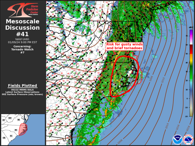
   Mesoscale Discussion 0041
   NWS Storm Prediction Center Norman OK
   0625 PM CST Tue Jan 09 2024

   Areas affected...Middle Atlantic

   Concerning...Tornado Watch 7...

   Valid 100025Z - 100200Z

   The severe weather threat for Tornado Watch 7 continues.

   SUMMARY...Gusty winds, along with the threat for brief tornadoes,
   are expected with convection this evening.

   DISCUSSION...Strong, large-scale forcing is spreading across the
   middle Atlantic early this evening ahead of an approaching trough.
   An expansive corridor of pre-frontal convection has developed in
   response to this forcing, currently extending from southeast VA,
   south across the eastern Carolinas. Surface dew points will struggle
   to rise above 63-65F across the warm sector which is limiting
   instability within a poor lapse rate environment. Latest diagnostic
   data suggests the only meaningful buoyancy is located across
   southeast NC where MLCAPE is on the order of 500 J/kg; although,
   offshore buoyancy is likely considerably higher (in excess of 1000
   J/kg). Radar data supports this with strong, long-lived rotating
   updrafts noted about 50 mi offshore. These supercells are advancing
   northeast, but have weakened a bit as they spread inland where
   buoyancy is weaker. Even so, strong shear is expected to maintain
   these updrafts as they track across the eastern portions of NC this
   evening. Damaging gusts can be expected with the organized
   convection and some risk for brief tornadoes continue, especially
   with the supercells near the higher buoyancy.

   ..Darrow.. 01/10/2024

   ...Please see www.spc.noaa.gov for graphic product...

   ATTN...WFO...AKQ...MHX...RAH...ILM...

   LAT...LON   34027805 36837747 36547554 34627607 34027805
|


 @NWSSPC