|
| Mesoscale Discussion 69 |
|
< Previous MD Next MD >
|
|
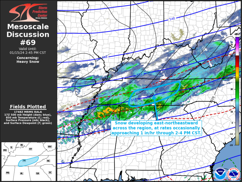
   Mesoscale Discussion 0069
   NWS Storm Prediction Center Norman OK
   1150 AM CST Mon Jan 15 2024

   Areas affected...parts of middle and eastern Tennessee

   Concerning...Heavy snow

   Valid 151750Z - 152045Z

   SUMMARY...An area of heavier snow rates, occasionally approaching 1
   inch per hour, may be maintained east-northeastward across portions
   of middle and eastern Tennessee through 2-4 PM CST, before gradually
   diminishing through early evening.

   DISCUSSION...A mid-level speed maximum propagating across northern
   Mississippi is forecast to reach the Cumberland Plateau by early
   evening.  This  still appears associated with an area of enhanced
   mid/upper forcing for ascent, which might be maintained through the
   20-22Z time frame while overspreading portions of middle through
   eastern Tennessee.  Thereafter, frontogenetic forcing is forecast to
   generally weaken across the Tennessee Valley through southern
   Appalachians vicinity, yielding diminishing precipitation rates.
   Until then, it appears that the area of enhanced lift will include
   upward vertical motion maximized within the favorably cold mid-level
   layer (centered around or above 600 mb) for large dendritic ice
   crystal growth.  It appears this may remain strong enough to support
   continuing potential for occasional heavy snow rates up to around 1
   inch per hour, where lower/mid tropospheric profiles are maintained
   at or below freezing (roughly north of the 0 C isotherm at 859 mb).

   ..Kerr.. 01/15/2024

   ...Please see www.spc.noaa.gov for graphic product...

   ATTN...WFO...MRX...OHX...HUN...

   LAT...LON   34978743 35118584 35718402 36408364 36298463 36048579
               35848708 34978743
|
|
Top/All Mesoscale Discussions/Forecast Products/Home
|
|


 @NWSSPC