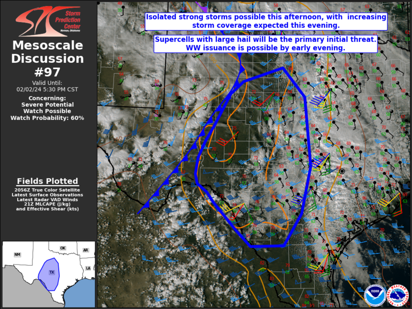
   Mesoscale Discussion 0097
   NWS Storm Prediction Center Norman OK
   0303 PM CST Fri Feb 02 2024

   Areas affected...South-central into northwest TX

   Concerning...Severe potential...Watch possible

   Valid 022103Z - 022330Z

   Probability of Watch Issuance...60 percent

   SUMMARY...Isolated strong storm development is possible late this
   afternoon, and will become increasingly likely this evening. Large
   hail is expected to be the primary threat, though isolated severe
   gusts and possibly a tornado cannot be ruled out. Watch issuance is
   possible by late afternoon or early evening.

   DISCUSSION...At 2045 UTC, a Pacific cold front/effective dryline
   extended from the western TX Panhandle southeastward into parts of
   northwest TX, and then southwestward toward western portions of the
   Edwards Plateau into the Big Bend region. High-based convection has
   developed west of the front across the Permian Basin region, in
   association with deep mixing and large-scale ascent attendant to a
   upper-level trough that is approaching west TX from the southern
   Rockies. East of the front, low-level moisture remains rather modest
   with dewpoints in the 50s F, but MLCAPE is still expected to
   increase into the 1000-1500 J/kg range as cold temperatures aloft
   (-18C to -20C at 500 mb) and steep midlevel lapse rates overspread
   the region.

   While substantial capping persists across the warm sector, continued
   heating along the western periphery of the low-level moist axis will
   act to reduce MLCINH through late afternoon. With time, ongoing
   high-based convection may intensify as it moves into better
   moisture/instability, with additional development possible near the
   front by early evening from northwest TX southward to near the Rio
   Grande.

   The onset of the greater severe threat remains somewhat uncertain,
   and may hold off until early evening, when stronger large-scale
   ascent begins to impinge across the warm sector. The most
   conditionally favorable environment is expected to evolve over the
   Edwards Plateau/south-central TX, where stronger mid/upper-level
   flow and greater hodograph elongation is expected this evening.
   Isolated supercells capable of large to very large hail will be
   possible in this area, with some threat for localized severe gusts
   and possibly a tornado, depending on the extent to which
   surface-based convection can be sustained. A few organized
   cells/clusters will also be possible into parts of northwest TX.
   Watch issuance is possible in order to cover these threats, though
   timing remains somewhat uncertain.

   ..Dean/Goss.. 02/02/2024

   ...Please see www.spc.noaa.gov for graphic product...

   ATTN...WFO...FWD...CRP...EWX...SJT...MAF...

   LAT...LON   29580151 29820185 30100191 30580184 31080160 31520130
               32480075 32830031 33249894 32369818 30339802 28969835
               28039895 28029945 28000006 28460053 29290129 29580151
|


 @NWSSPC