|
| Mesoscale Discussion 109 |
|
< Previous MD Next MD >
|
|
Mesoscale Discussion 0109
NWS Storm Prediction Center Norman OK
0447 PM CST Sun Feb 04 2024
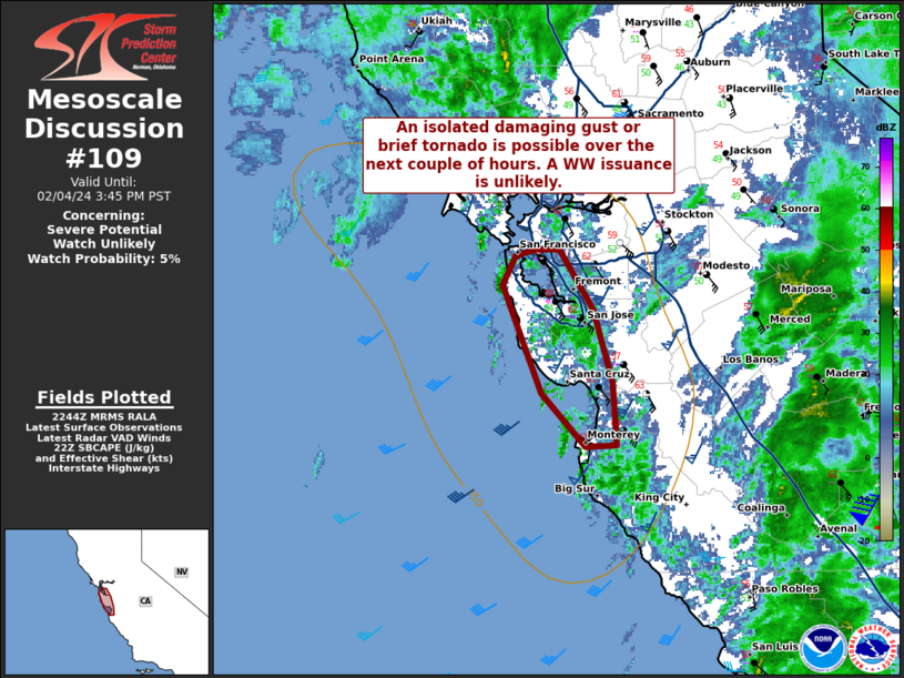
Areas affected...portions of the California coastline
Concerning...Severe potential...Watch unlikely
Valid 042247Z - 042345Z
Probability of Watch Issuance...5 percent
SUMMARY...A damaging gust or brief tornado cannot be ruled out over
the next couple of hours. A WW issuance is not expected.
DISCUSSION...A potent mid-level trough and associated surface
cyclone continues to meander off of the CA coastline. Recently,
surface-based buoyancy has begun to impinge on the CA coastline
south of the Bay area, with somewhere between 250-500 J/kg SBCAPE
(shown by 22z mesoanalysis) preceding an approaching confluence band
with gradually deepening convective cells. The CAPE profile is thin.
However, lapse rates are steep, and both RAP forecast soundings and
the latest MUX VAD shows a very long but slightly curved hodograph,
with nearly 300 m2/s2 SRH in 0-1 km layer alone. With 50+ kt flow
just off of the surface, any downward momentum transport within the
low-topped storms may support a severe gust. A brief tornado also
cannot be ruled out, though the relatively unidirectional shear may
temper this threat somewhat. The severe threat should begin to wane
with the onset of nocturnal cooling. The severe threat should remain
isolated and a WW issuance is not anticipated.
..Squitieri/Thompson.. 02/04/2024
...Please see www.spc.noaa.gov for graphic product...
ATTN...WFO...MTR...
LAT...LON 36962167 36582164 36572188 36902223 37562253 37752243
37782227 37782209 37412183 36962167
|
|
Top/All Mesoscale Discussions/Forecast Products/Home
|
|


 @NWSSPC