|
| Mesoscale Discussion 122 |
|
< Previous MD Next MD >
|
|
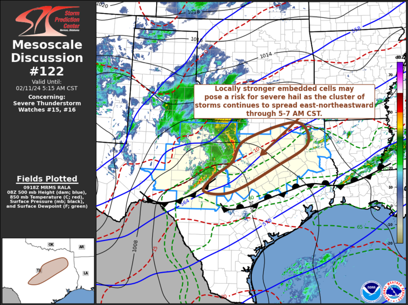
   Mesoscale Discussion 0122
   NWS Storm Prediction Center Norman OK
   0320 AM CST Sun Feb 11 2024

   Areas affected...central into northeastern Texas

   Concerning...Severe Thunderstorm Watch 15...16...

   Valid 110920Z - 111115Z

   The severe weather threat for Severe Thunderstorm Watch 15, 16
   continues.

   SUMMARY...A cluster of thunderstorms will overspread the Interstates
   35 and 45 into 20 corridors of central into northeastern Texas
   through 5-7 AM CST, with a few embedded stronger storms posing a
   risk for severe hail.

   DISCUSSION...As the primary mid-level jet streak (including 70-90 kt
   around 500 mb) continues to propagate across the Texas Big Bend into
   the Edwards Plateau through 11-13Z, relatively warm and/or warming
   lower/mid-tropospheric air appears likely to be maintained above
   potentially unstable boundary layer air now present across the lower
   Rio Grande Valley and Texas coastal plain.  Stronger forcing for
   ascent and associated convective development probably will remain
   focused well to the north of the quasi-stationary to slow moving
   warm frontal zone, now roughly near/north of San Antonio through the
   College Station and Huntsville vicinities.

   To the north of the frontal zone, forecast soundings suggest that
   the cool near-surface layer remains stable with regard to potential
   for strong downdrafts to reach the surface.  Furthermore, lower
   tropospheric wind fields preceding the convective cluster are rather
   modest in strength, and there is little indication of strong
   lower/mid-tropospheric rear-inflow developing, despite the organized
   character of the elevated convection.  So the potential for strong
   convective wind gusts appears likely to remain low through at least
   11-13Z. But elevated instability and favorable cloud-bearing layer
   shear may continue to support locally strong embedded supercell
   structures posing a risk for severe hail as convection spreads
   across the I-35/45 into I-20 corridors of central through
   northeastern Texas.

   ..Kerr.. 02/11/2024

   ...Please see www.spc.noaa.gov for graphic product...

   ATTN...WFO...SHV...FWD...EWX...SJT...

   LAT...LON   32319767 32999536 32169483 31279628 30309824 30309949
               30879910 31439826 32319767
|
|
Top/All Mesoscale Discussions/Forecast Products/Home
|
|


 @NWSSPC