|
| Mesoscale Discussion 134 |
|
< Previous MD Next MD >
|
|
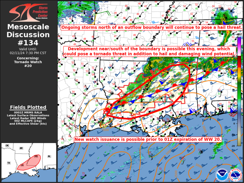
   Mesoscale Discussion 0134
   NWS Storm Prediction Center Norman OK
   0605 PM CST Sun Feb 11 2024

   Areas affected...Parts of LA into central/southern MS

   Concerning...Tornado Watch 20...

   Valid 120005Z - 120130Z

   The severe weather threat for Tornado Watch 20 continues.

   SUMMARY...Large hail will continue to be the primary threat north of
   an outflow boundary. Storm development remains possible near/south
   of the boundary this evening, which would potentially pose a tornado
   threat in addition to hail and damaging-wind potential. New watch
   issuance is possible prior to the expiration of WW 20.

   DISCUSSION...An outflow boundary extends from southwest LA into
   southern MS early this evening. Ongoing convection is largely
   elevated and focused north of the boundary, but MUCAPE of 500-1000
   J/kg and strong deep-layer shear are supporting elevated supercell
   potential, which will continue to pose a large hail threat through
   much of the evening.

   The composite outflow continues to sag slowly southward, especially
   in areas where convection is in close proximity to the boundary. In
   the near term, this tendency will limit potential for surface-based
   convection. However, increasing large-scale ascent attendant to an
   approaching mid/upper-low over the southern Plains may allow for
   increasing storm potential near/south of the boundary later this
   evening. Strengthening low-level flow/shear would support some
   tornado potential if surface-based convection can be sustained
   across parts of southern LA/MS.

   With some severe threat likely to persist through much of the
   evening, new watch issuance is possible prior to the 01Z expiration
   of WW 20.

   ..Dean/Hart.. 02/12/2024

   ...Please see www.spc.noaa.gov for graphic product...

   ATTN...WFO...JAN...LIX...LCH...SHV...

   LAT...LON   30929317 31439221 32569035 32778987 32848916 32628885
               32218881 31848897 31408924 30918978 30739018 30589066
               30389131 30169227 30199293 30329356 30929317
|
|
Top/All Mesoscale Discussions/Forecast Products/Home
|
|


 @NWSSPC