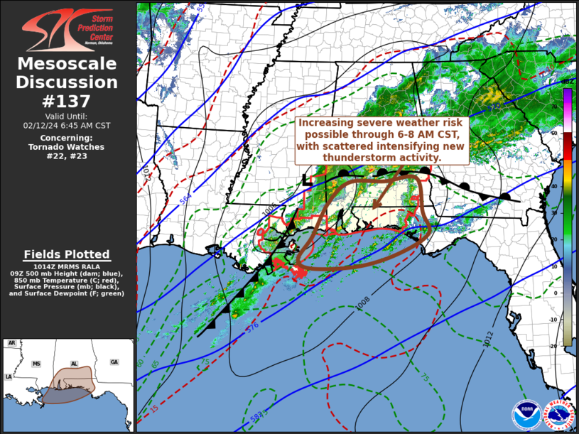
   Mesoscale Discussion 0137
   NWS Storm Prediction Center Norman OK
   0416 AM CST Mon Feb 12 2024

   Areas affected...parts of far southeastern Mississippi...southern
   Alabama and the western Florida Panhandle

   Concerning...Tornado Watch 22...23...

   Valid 121016Z - 121245Z

   The severe weather threat for Tornado Watch 22, 23 continues.

   SUMMARY...While the ongoing, slowly eastward advancing line of
   storms may continue to weaken into and beyond daybreak, intensifying
   new thunderstorm development ahead of it may begin to pose
   increasing potential for at least severe hail and locally damaging
   wind gusts.

   DISCUSSION...Mid/upper flow appears to trending increasingly
   difluent across the north central into northeastern Gulf coast
   vicinity, as a significant upstream short wave trough begins to take
   on more of a neutral to negative tilt across the southern Great
   Plains toward the lower Mississippi Valley.  Beneath this regime,
   increasing large-scale ascent, aided by low-level warm advection,
   likely is contributing to an increase in convective development
   offshore of southeastern Louisiana coastal areas into southern
   Alabama and the western Florida Panhandle.

   Across and inland of the coastal waters a shallow moist adiabatic or
   more stable near-surface layer appears to linger based on model
   forecast soundings.  However, CAPE for slightly elevated most
   unstable parcels might be as high as 1000 J/kg, which may support a
   continuing increase and intensification of this newer thunderstorm
   development.  Latest trends appear to support the High Resolution
   Rapid Refresh depiction that this will become the most prominent
   thunderstorm activity into and beyond daybreak, while the trailing
   ongoing pre-frontal line of thunderstorms dissipates.

   It appears that this may coincide with notable strengthening of a
   southerly low-level jet off the Gulf of Mexico (40-50+ kt around 850
   mb), with forecasts soundings exhibiting enlarging low-level
   hodographs at least somewhat more conducive to supercells structures
   potentially supportive of a risk for tornadoes.  Otherwise, stronger
   new thunderstorm development may gradually pose increasing potential
   for severe hail and locally damaging surface gusts.

   ..Kerr.. 02/12/2024

   ...Please see www.spc.noaa.gov for graphic product...

   ATTN...WFO...TAE...BMX...MOB...LIX...

   LAT...LON   30158885 31098837 31678769 31708655 31778553 30848535
               30258516 29728609 29368737 29278885 29518929 30158885
|


 @NWSSPC