|
| Mesoscale Discussion 160 |
|
< Previous MD Next MD >
|
|
Mesoscale Discussion 0160
NWS Storm Prediction Center Norman OK
0845 AM CST Tue Feb 27 2024
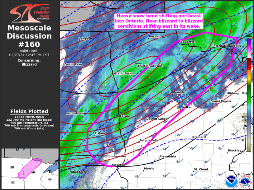
Areas affected...Northwest to north-central MN and southeast ND
Concerning...Blizzard
Valid 271445Z - 271845Z
SUMMARY...A band of persistent heavy snow with 1-2 inch/hour rates
will shift northeast across northwest and north-central Minnesota
into northwest Ontario. Near-blizzard to blizzard conditions should
continue in its wake where light to moderate snow occurs, mainly
across the Red River Valley.
DISCUSSION...Based on observed snow reports and imagery, a band of
heavy snow is ongoing from the Fargo-Moorhead vicinity northeastward
across northwest MN. This heavy snow band aligns well with 700-mb
frontogenesis and is expected to shift northeast across
north-central MN into northwest Ontario through midday. Meanwhile,
strong to severe gradient winds (gust to 51 kts measured at KFAR)
near and to the backside of this heavy snow band has yielded several
obs with visibility of a half-mile or less. The bulk of the tighter
surface pressure gradient and low-level flow should generally shift
east into the afternoon, suggesting the more persistent
near-blizzard to blizzard conditions should be favored over the Red
River Valley and parts of northwest MN.
..Grams.. 02/27/2024
...Please see www.spc.noaa.gov for graphic product...
ATTN...WFO...DLH...FGF...ABR...
LAT...LON 46569792 47439686 48389538 48769471 48999362 48829246
48129275 46499545 45939613 45749653 45689715 45789757
46079791 46569792
|
|
Top/All Mesoscale Discussions/Forecast Products/Home
|
|


 @NWSSPC