|
| Mesoscale Discussion 165 |
|
< Previous MD Next MD >
|
|
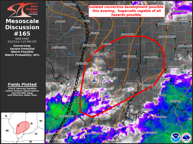
   Mesoscale Discussion 0165
   NWS Storm Prediction Center Norman OK
   0547 PM CST Tue Feb 27 2024

   Areas affected...parts of central and southern Illinois into Western
   Indiana

   Concerning...Severe potential...Watch possible

   Valid 272347Z - 280115Z

   Probability of Watch Issuance...40 percent

   SUMMARY...Isolated storm development along the dryline is possible
   early this evening. Experimental WOFS guidance and environmental
   analysis suggest conditional severe potential if supercells are able
   to develop.

   DISCUSSION...As of 2230 UTC, regional satellite data showed towering
   altocumulus deepening across parts of central IL. Located along the
   dryline ahead of a subtle shortwave trough, multiple attempts at CI
   appear to be underway. The environment downstream of the dryline is
   conditionally favorable for deep convection, with dewpoints in the
   upper 50s to low 60s F and steep mid-level lapse rates supporting
   1500-2000 J/kg of MLCAPE. Considerable MLCINH (-100 J/kg from
   mesoanalysis) remains in place, but if deep convection can initiate,
   50+ kt of effective shear would favor storm organization with a
   supercellular mode.

   Hi-res and experimental forecast guidance has shown isolated storm
   development early this evening over several prior runs. Should this
   occur, the environment over eastern IL and western IN is favorable
   for supercells capable of all severe hazards. ESRH of 300-400 m2/s2,
   observed from area VWPs, may also support a risk for a strong
   tornado. While the risk remains very uncertain, given dry air
   entertainment and the loss of diurnal heating along the dryline,
   observational trends are being monitored for a possible weather
   watch. Storm development is much more likely later this evening as
   the cold front and stronger forcing for ascent approach from the
   west after 03z.

   ..Lyons/Edwards.. 02/27/2024

   ...Please see www.spc.noaa.gov for graphic product...

   ATTN...WFO...IND...PAH...ILX...LSX...

   LAT...LON   37958969 37818925 38028870 38298808 38718704 39138667
               39608666 39778676 39958695 40108734 40118805 40038834
               39808890 39598926 39298952 38418970 37958969
|
|
Top/All Mesoscale Discussions/Forecast Products/Home
|
|


 @NWSSPC