|
| Mesoscale Discussion 239 |
|
< Previous MD Next MD >
|
|
Mesoscale Discussion 0239
NWS Storm Prediction Center Norman OK
0509 PM CDT Thu Mar 14 2024
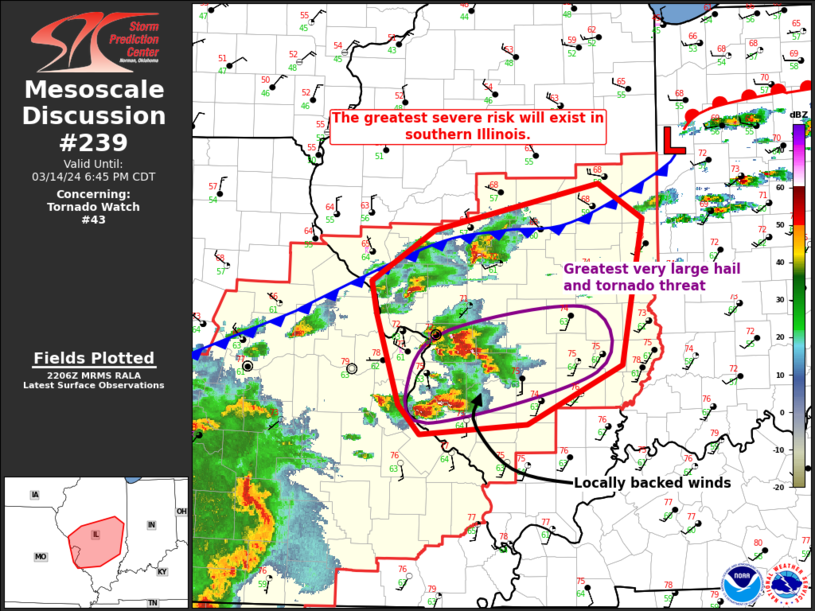
Areas affected...Portions of east-central Missouri into
central/southern Illinois
Concerning...Tornado Watch 43...
Valid 142209Z - 142345Z
The severe weather threat for Tornado Watch 43 continues.
SUMMARY...The greatest risk for very large hail and tornadoes in the
next 1-2 hours will be in southern Illinois. Intense storms near the
cold front will eventually be overtaken by the front and undergo a
weakening trend.
DISCUSSION...A cluster of supercell storms continues east/southeast
of the St. Louis area. A secondary cluster is also ongoing near the
cold front in west-central/central Illinois. An area of locally
backed surface winds is evident in surface observations ahead of the
more southern cluster of supercells. Despite only modest low-level
shear, this area will pose the greatest risk for tornadoes in the
next hour or two. These storms will also pose a risk of 2-3 inch
hail.
Farther north near the cold front, the threat for tornadoes should
be less. Large/very-large hail will continue to be a threat given
favorable deep-layer shear and storm mode. With the cold front also
beginning to make southward progress, the duration of the severe
threat may be more short-lived farther north. Buoyancy will decrease
behind the front and is not expected to support strong/severe
elevated storms.
..Wendt.. 03/14/2024
...Please see www.spc.noaa.gov for graphic product...
ATTN...WFO...PAH...ILX...LSX...
LAT...LON 38029022 38279047 39079072 39379078 39829006 40228821
39918770 38628794 38108902 38029022
|
|
Top/All Mesoscale Discussions/Forecast Products/Home
|
|


 @NWSSPC