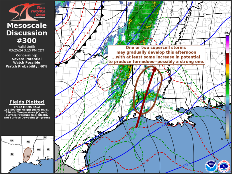
   Mesoscale Discussion 0300
   NWS Storm Prediction Center Norman OK
   1220 PM CDT Mon Mar 25 2024

   Areas affected...parts of western/northern Louisiana and adjacent
   southern Arkansas

   Concerning...Severe potential...Watch possible

   Valid 251720Z - 252015Z

   Probability of Watch Issuance...40 percent

   SUMMARY...Potential exists for one or two supercell storms to
   gradually develop this afternoon, particularly near/west of the
   Alexandria through Monroe vicinities by 3-4 PM CDT, if not earlier.
   This may be accompanied by increasing risk to produce
   tornadoes--perhaps a strong one.

   DISCUSSION...In advance of a pre-frontal low-level wind
   shift/confluence zone slowly advancing eastward across parts of
   western Arkansas and eastern Texas, new thunderstorm development has
   initiated across upper Texas and southwestern Louisiana coastal
   areas.  This appears to be in response to low-level moistening and
   lift within a fairly strong warm advection regime, which may be
   maximized near or just above 850 mb.

   This is forecast to continue to shift north-northeastward toward
   north central Louisiana, near/west of Monroe, through 20-21Z, where
   somewhat weaker mid-level inhibition and increasing mid/upper
   forcing beneath more pronounced difluent flow aloft may support
   thunderstorm intensification.  Given the strong deep-layer shear,
   and forecast of enlarging low-level hodographs beneath strengthening
   southerly 850 flow (to 50+ kt), the structure of the near-surface
   thermodynamic profiles remains the primary uncertainty concerning
   severe weather potential.

   For example, notable differences are evident between the NAM and
   Rapid Refresh forecast soundings, with the NAM soundings suggesting
   convection may remain elevated above a saturated but weakly stable
   profile from the surface through around 850 mb.  Lapse rates within
   this layer in the Rapid Refresh forecast soundings appear at least
   somewhat more unstable, and perhaps supportive of convection rooted
   closer to the surface, where hodographs within the low-level inflow
   layer may be more conducive to the evolution of strong low-level
   mesocyclones.

   ..Kerr/Hart.. 03/25/2024

   ...Please see www.spc.noaa.gov for graphic product...

   ATTN...WFO...JAN...LCH...SHV...

   LAT...LON   30549391 32379358 33199256 32489169 31259207 30369248
               29969331 30549391
|


 @NWSSPC