|
| Mesoscale Discussion 314 |
|
< Previous MD Next MD >
|
|
Mesoscale Discussion 0314
NWS Storm Prediction Center Norman OK
0609 PM CDT Sat Mar 30 2024
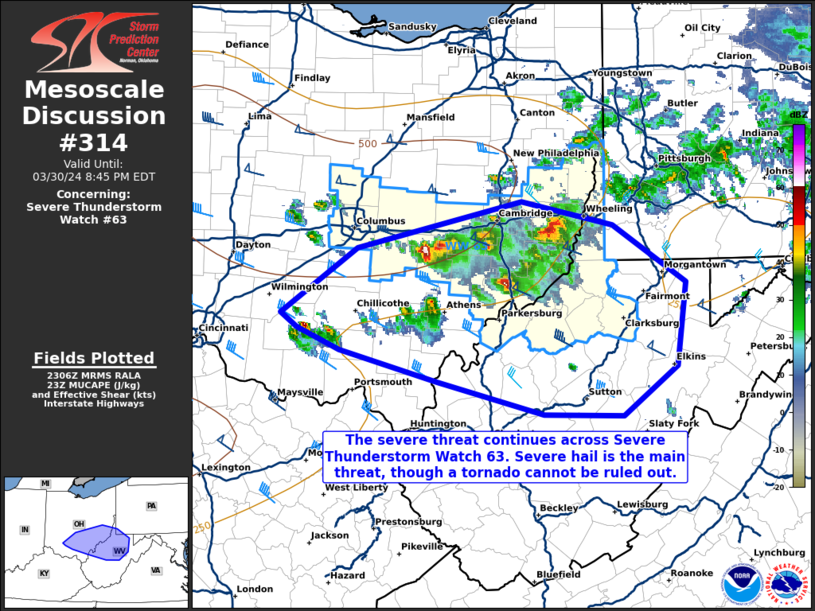
Areas affected...portions of southern and eastern OH into extreme
southwest PA and northern WV
Concerning...Severe Thunderstorm Watch 63...
Valid 302309Z - 310045Z
The severe weather threat for Severe Thunderstorm Watch 63
continues.
SUMMARY...Severe hail remains the primary concern with ongoing
storms across Severe Thunderstorm Watch 63, though a tornado cannot
be ruled out. These storms should persist for at least a few more
hours while rapidly moving southeast. Local watch extensions may be
needed in the next few hours ahead of the more robust storms.
DISCUSSION...Multiple discrete/semi-discrete supercells are ongoing
across portions of central into southeastern OH, which have produced
several instances of 1+ inch hail over the past few hours, as well
as persistent tracks of 1+ inch MESH tracks per MRMS mosaic radar
data. These storms are tracking along the eastern extent of a 7+
C/km mid-level lapse rate plume, which also overspreads a surface
thermal ridge that is contributing to a well-mixed boundary layer.
Both 22Z mesoanalysis and some of the latest regional VADs all
depict elongated hodographs well downstream of the ongoing storms.
Given the steep mid-level lapse rates and strong deep-layer shear,
additional instances of severe hail are expected into the evening
hours. Since there is some appreciable low-level curvature to the
hodographs, a tornado cannot be completely ruled out, though very
limited low-level moisture should limit the tornado threat.
Many of the ongoing storms have forward speeds at or above 40 kts,
suggesting that some of these storms may reach the southern and
eastern bounds of Severe Thunderstorm Watch 63 before severe hail
potential diminishes. As such, WW spatial extensions may be needed
over the next few hours pending convective trends.
..Squitieri.. 03/30/2024
...Please see www.spc.noaa.gov for graphic product...
ATTN...WFO...PBZ...RLX...ILN...
LAT...LON 39818296 40168134 39998044 39547972 38917981 38538034
38548112 38798217 39028312 39198354 39318370 39818296
|
|
Top/All Mesoscale Discussions/Forecast Products/Home
|
|


 @NWSSPC