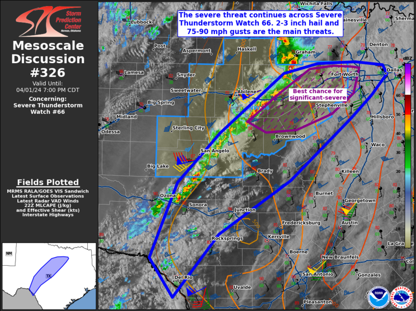
   Mesoscale Discussion 0326
   NWS Storm Prediction Center Norman OK
   0526 PM CDT Mon Apr 01 2024

   Areas affected...portions of western Texas

   Concerning...Severe Thunderstorm Watch 66...

   Valid 012226Z - 020000Z

   The severe weather threat for Severe Thunderstorm Watch 66
   continues.

   SUMMARY...The severe threat continues across Severe Thunderstorm
   Watch 66. Very large hail and hurricane-force gusts will remain
   possible with the strongest storms through evening, and a tornado
   cannot be ruled out. Storms may develop farther south across
   southwestern into central TX and local WW extensions or new watches
   may eventually become necessary.

   DISCUSSION...Semi-discrete storms, including supercells, have been
   progressing eastward across portions of northwestern TX with a
   history of up to baseball sized hail and near 90 mph measured gusts.
   Diurnal heating ahead of the ongoing line of storms has allowed for
   surface temperatures to warm to over 80 F amid upper 60s F
   dewpoints, minimizing CINH and boosting MLCAPE to 2000 J/kg (per 22Z
   mesoanalysis). Buoyancy is modest, but more than adequate in
   supporting continued significant-severe weather given the presence
   of 80+ kts of effective bulk shear (driven by a 30+ kt low-level jet
   overspread by over 80 kts of 500 mb southwesterly flow). As such,
   the more sustained supercell structures may continue to produce
   severe hail in the 2-3 inch diameter range, along with severe gusts
   peaking between 75-90 mph. The best chance for significant-severe
   storms will be over northwestern into north-central TX, where
   deep-layer ascent is the strongest. Additionally, regional VADs and
   22Z mesoanalysis does show some slight low-level hodograph
   curvature, suggesting that a tornado cannot be ruled out as well.

   Farther south, storms are attempting to develop closer to the Rio
   Grande. However, overall forcing for ascent is weaker, raising
   questions pertaining to storm coverage. Still, given the strong
   deep-layer shear present, any storms that can mature and become
   sustained will present a severe hail/wind risk. A local spatial
   extension of Severe Thunderstorm Watch 66 may be needed if
   confidence in convective coverage increases farther south into
   southern and central TX.

   ..Squitieri.. 04/01/2024

   ...Please see www.spc.noaa.gov for graphic product...

   ATTN...WFO...FWD...EWX...SJT...

   LAT...LON   29080091 29730135 30990084 31810003 32809879 32969812
               32999740 32939686 32789678 32429708 32059749 31029868
               30130005 29080091
|


 @NWSSPC