The SPC is forecasting ...severe thunderstorms expected over parts of the lower mississippi valley beginning this afternoon and increasing tonight and early wednesday... the nws storm prediction center in norman ok is forecasting the development of a few strong tornadoes over parts of the lower mississippi valley tonight through early wednesday. the areas most likely to experience this activity include southern arkansas northern louisiana northern and central mississippi surrounding the moderate risk area...there is a slight risk of severe thunderstorms from eastern oklahoma and northern arkansas south to the western and central gulf coast a very strong jet stream disturbance...with high level wind speeds above 130 mph...will sweep rapidly southeast across the central rockies later today...and into oklahoma...north texas and the lower mississippi valley tonight and early wednesday. the disturbance will be accompanied by an intensifying surface low that will track east along the red river valley this evening to central arkansas by dawn wednesday. the low will draw warm and unseasonably humid air northward from the gulf of mexico beneath the increasing westerly flow aloft. as the warm humid air encounters the low and its associated warm and cold fronts...thunderstorms likely will form over parts of arkansas...louisiana and mississippi. while some storms could appear as early as this afternoon...more widespread and intense activity is expected tonight through early wednesday. given the very strong winds and rich moisture available to these storms...and the uplift provided by the intensifying low.... Please read the latest public statement about this event.
| Categorical Graphic |
|---|

|
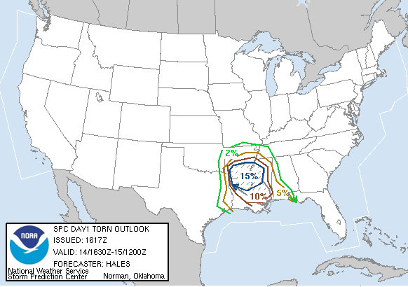
| Probabilistic Tornado Graphic |
 |
 |
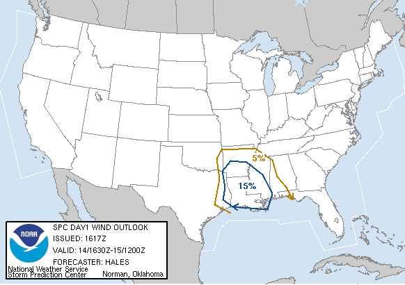
| Probabilistic Damaging Wind Graphic |
 |
 |
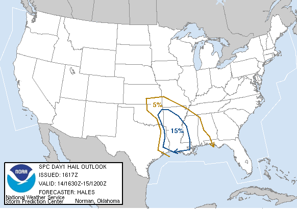
| Probabilistic Large Hail Graphic |
 |
 |
   SPC AC 141617

   DAY 1 CONVECTIVE OUTLOOK
   NWS STORM PREDICTION CENTER NORMAN OK
   1017 AM CST TUE NOV 14 2006

   VALID 141630Z - 151200Z

   ...THERE IS A MDT RISK OF SVR TSTMS OVER PARTS OF SRN AND ERN
   AR...NRN AND ERN LA...AND WRN/CENTRAL MS......

   ...THERE IS A SLGT RISK OF SVR TSTMS SURROUNDING THE MDT RISK AREA
   FROM ERN OK SE TO THE CENTRAL GULF COAST...

   ...SYNOPSIS...
   INTENSE AMPLIFICATION OF VIGOROUS TROUGH NOW CROSSING NRN
   INTERMOUNTAIN REGION UNDERWAY AND BY THE END OF THE FORECAST
   PERIOD/12Z WED/ A DEEP CLOSED LOW WILL BE LOCATED IN SRN OK. VERY
   STRONG WIND FIELDS AT ALL LEVELS WILL BE ROTATING ACROSS SRN PLAINS
   TONIGHT WHICH ALONG WITH THE STRONG UPWARD MOTION WILL PROVIDE
   FAVORABLE KINEMATICS FOR SEVERE THUNDERSTORMS INCLUDING POTENTIAL
   FOR TORNADIC SUPERCELLS.

   WHILE THE TIME OF DAY/OVERNIGHT/ AND STABILIZING EFFECT OF ONGOING
   CONVECTION THAT WILL DEVELOP THIS AFTERNOON COULD MITIGATE SOMEWHAT
   THE SEVERE THREAT...THE INTENSITY OF THE SYSTEM COUPLED WITH
   AVAILABILITY OF A POTENTIALLY UNSTABLE AIR MASS NOW ONSHORE WRN GULF
   COAST IS THE OVERRIDING CONSIDERATION IN CONTINUING THE MDT RISK OF
   SEVERE TONIGHT.

   ...LOWER MS VALLEY..
   SURFACE LOW WILL RAPIDLY DEEPEN LEE OF CENTRAL ROCKIES THIS
   AFTERNOON AND TRACK ESEWD ACROSS OK TONIGHT. WARM FRONT CENTRAL TX
   ESEWD TO OFFSHORE SRN LA WILL LIFT NWD THIS AFTERNOON AS 30KT SWLY
   LLJ SPREADS THE MOIST/UNSTABLE AIR MASS NEWD ACROSS LOWER MS VALLEY.
    SHEAR PROFILES CURRENTLY IN PLACE VICINITY WARM FRONT ALREADY
   SUPPORT SUPERCELL POTENTIAL WELL IN ADVANCE OF THE INTENSE DIGGING
   GOING ON UPSTREAM. WITH HEATING THIS AFTERNOON RAISING MLCAPES TO
   NEAR 1500 J/KG SERN TX AND SRN LA AND ENHANCED SHEAR VICINITY OF
   WARM FRONT...STRONG/SEVERE THUNDERSTORMS WILL BECOME AN INCREASING
   THREAT.  WITH SFC-1KM SHEAR OF 25-30KT VICINITY OF WARM FRONT ALONG
   WITH DEEP LAYER SHEAR OF 40KT A FEW SUPERCELLS ARE POSSIBLE ALONG
   WITH A TORNADO THREAT.

   THE PRIMARY SEVERE THREAT WILL DEVELOP OVERNIGHT AS WARM FRONT
   CONTINUES TO SURGE NWD INTO SRN AR/CENTRAL MS AND THE FORCING
   ASSOCIATED WITH DEEPENING TROUGH UPSTREAM BEGIN TO INTERACT.

   OVERNIGHT...SUPERCELLS ALONG WITH A TORNADO THREAT WILL BE ON THE
   INCREASE PARTICULARLY VICINITY THE ENHANCED SHEAR AND LIFT OF THE
   WARM FRONT.  AS THE 100-120KT MID LEVEL JET MAX ROTATES ACROSS SRN
   PLAINS INTO LOWER MS VALLEY...POTENTIAL FOR STRONG TORNADOS WILL BE
   ON THE INCREASE ACROSS SRN AR/NRN LA AND INTO WRN MS.

   ..HALES/LEVIT.. 11/14/2006

   CLICK TO GET WUUS01 PTSDY1 PRODUCT

   NOTE: THE NEXT DAY 1 OUTLOOK IS SCHEDULED BY 2000Z