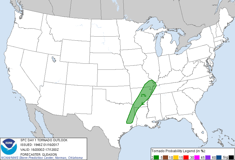
Memphis, TN...Shreveport, LA...Little Rock, AR...Longview, TX...Bossier City, LA...
Probabilistic Tornado Graphic
Probability of a tornado within 25 miles of a point. Hatched Area: 10% or greater probability of EF2 - EF5 tornadoes within 25 miles of a point.
Day 1 Tornado Risk
Area (sq. mi.)
Area Pop.
Some Larger Population Centers in Risk Area
2 %
58,501
3,697,492
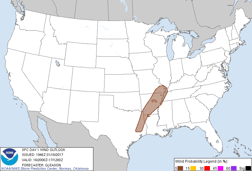
Memphis, TN...Shreveport, LA...Little Rock, AR...Longview, TX...Bossier City, LA...
Probabilistic Damaging Wind Graphic
Probability of damaging thunderstorm winds or wind gusts of 50 knots or higher within 25 miles of a point. Hatched Area: 10% of greater probability of wind gusts 65 knots or greater within 25 miles of a point.
Day 1 Wind Risk
Area (sq. mi.)
Area Pop.
Some Larger Population Centers in Risk Area
5 %
62,702
4,246,630
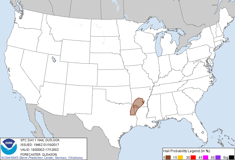
Memphis, TN...Shreveport, LA...Little Rock, AR...Longview, TX...Bossier City, LA...
Probabilistic Large Hail Graphic
Probability of hail 1" or larger within 25 miles of a point. Hatched Area: 10% or greater probability of hail 2" or larger within 25 miles of a point.
Day 1 Hail Risk
Area (sq. mi.)
Area Pop.
Some Larger Population Centers in Risk Area
5 %
19,359
1,301,577
Shreveport, LA...Longview, TX...Bossier City, LA...Hot Springs, AR...Texarkana, TX...
   SPC AC 161946

   Day 1 Convective Outlook
   NWS Storm Prediction Center Norman OK
   0146 PM CST Mon Jan 16 2017

   Valid 162000Z - 171200Z

   ...THERE IS A MARGINAL RISK OF SEVERE THUNDERSTORMS ACROSS THE
   ARKLATEX AND MID MISSISSIPPI RIVER VALLEY...

   ...SUMMARY...
   A few strong to severe thunderstorms remain possible this afternoon
   and early evening from the Arklatex region to the Mid Mississippi
   Valley. Strong to locally damaging winds, a brief tornado, and small
   to marginally severe hail are possible on an isolated basis.

   ...20Z Update...
   No appreciable changes have been made to the prior outlook. Latest
   visible satellite trends indicate cumulus building along a cold
   front from MO southwestward into east TX, and isolated to scattered
   convection is forecast to occur across this region. Modest diurnal
   heating has allowed surface temperatures to warm into the 50s north
   to upper 60s/mid 70s south. Weak instability amidst sufficient bulk
   shear across the Arklatex and mid MS Valley should support an
   isolated threat for strong to locally damaging wind gusts, a brief
   tornado, and perhaps some hail through the early evening hours. The
   loss of diurnal heating later this evening should temper the
   marginal severe risk as instability weakens and the prospect for
   surface-based convection diminishes.

   ..Gleason.. 01/16/2017

   .PREV DISCUSSION... /ISSUED 1027 AM CST Mon Jan 16 2017/

   ...East Texas/Arklatex/middle Mississippi Valley...
   A closed upper low over KS/northern OK at late morning will continue
   northeastward and reach the Lake Michigan vicinity by early Tuesday
   morning. Heights will rise across east TX coincident with a stalling
   front, while the cold front will remain more eastward progressive
   across the Ozarks/middle Mississippi River valley. Moderately strong
   south-southwesterly winds just above the surface will continue to
   transport a seasonally moist air mass northward, with near 60 F
   surface dewpoints reaching as far north as Memphis/northeast AR by
   early evening as air mass modification steadily occurs.

   Cloud cover may remain semi-prevalent across the warm sector today
   coincident with weak warm/moist advection amid a confluent
   pre-frontal regime. Even so, increasing moisture and cloud
   breaks/pockets of stronger heating could lead to MLCAPE around 500
   J/kg this afternoon. As at least some afternoon intensification of
   updrafts occurs, 35-45 kt of effective shear would support
   semi-organized updrafts and line segments, potentially capable of
   marginally severe hail, damaging winds, and/or a brief tornado
   through the afternoon and evening. Aside from cloud cover, a
   sub-optimal phasing of large-scale ascent and more prevalent
   moisture/surface-based instability (to the south) should limit the
   overall severe risk today.

   CLICK TO GET WUUS01 PTSDY1 PRODUCT

   NOTE: THE NEXT DAY 1 OUTLOOK IS SCHEDULED BY 0100Z