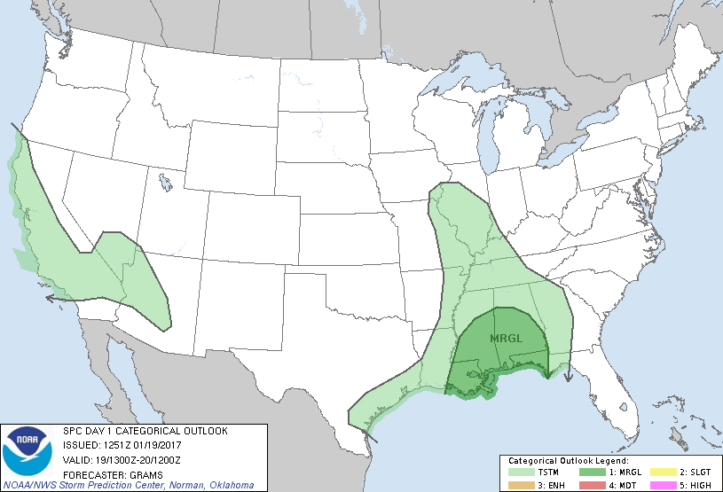
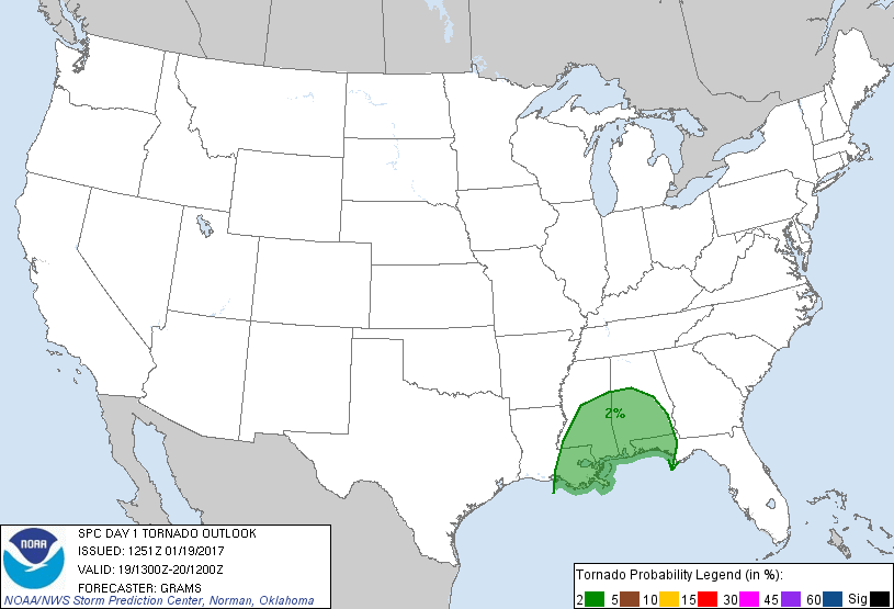
New Orleans, LA...Birmingham, AL...Baton Rouge, LA...Montgomery, AL...Mobile, AL...
Probabilistic Tornado Graphic
Probability of a tornado within 25 miles of a point. Hatched Area: 10% or greater probability of EF2 - EF5 tornadoes within 25 miles of a point.
Day 1 Tornado Risk
Area (sq. mi.)
Area Pop.
Some Larger Population Centers in Risk Area
2 %
81,261
7,181,661
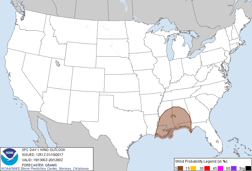
New Orleans, LA...Baton Rouge, LA...Montgomery, AL...Mobile, AL...Jackson, MS...
Probabilistic Damaging Wind Graphic
Probability of damaging thunderstorm winds or wind gusts of 50 knots or higher within 25 miles of a point. Hatched Area: 10% of greater probability of wind gusts 65 knots or greater within 25 miles of a point.
Day 1 Wind Risk
Area (sq. mi.)
Area Pop.
Some Larger Population Centers in Risk Area
5 %
92,755
8,324,954
New Orleans, LA...Birmingham, AL...Baton Rouge, LA...Montgomery, AL...Mobile, AL...
Probabilistic Large Hail Graphic
Probability of hail 1" or larger within 25 miles of a point. Hatched Area: 10% or greater probability of hail 2" or larger within 25 miles of a point.
Day 1 Hail Risk
Area (sq. mi.)
Area Pop.
Some Larger Population Centers in Risk Area
No Risk Areas Forecast
   SPC AC 191251

   Day 1 Convective Outlook
   NWS Storm Prediction Center Norman OK
   0651 AM CST Thu Jan 19 2017

   Valid 191300Z - 201200Z

   ...THERE IS A MARGINAL RISK OF SEVERE THUNDERSTORMS PARTS OF
   LA/MS/AL/FL...

   ...SUMMARY...
   A couple brief tornadoes and isolated damaging winds will be
   possible into tonight across parts of Louisiana, Mississippi,
   Alabama, and Florida.

   ...LA/MS/AL/FL...
   A broad swath of convection is ongoing from the Mid-South to the
   northwest Gulf. The strongest storms have been confined to parts of
   east-central LA to southwest MS, along the leading edge of the
   convective band where the inflow air mass is characterized by 65-70
   degree F surface dew points. The northern extent of this rich
   moisture should reach as far east as west-central AL into the FL
   Panhandle. However, weak mid/upper-level lapse rates sampled by 12Z
   soundings suggest that MLCAPE should remain meager, predominately
   around 500 J/kg or less. Nevertheless, some intensification of this
   morning's convection may occur through the afternoon/evening as
   low-level southwesterlies strengthen to around 35-45 kt at 850 mb.
   This should result in moderately enlarged low-level hodographs and
   support transient rotating updrafts given the weak instability.
   Overall scenario appears most likely to yield a brief tornado or two
   and isolated damaging winds. This risk should persist into the
   evening across parts of the central Gulf Coast, before gradually
   diminishing overnight.

   For additional short-term discussion, please see MCD 0074.

   ..Grams.. 01/19/2017

   CLICK TO GET WUUS01 PTSDY1 PRODUCT

   NOTE: THE NEXT DAY 1 OUTLOOK IS SCHEDULED BY 1630Z