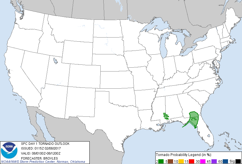
Probability of a tornado within 25 miles of a point. Hatched Area: 10% or greater probability of EF2 - EF5 tornadoes within 25 miles of a point.
Day 1 Tornado Risk
Area (sq. mi.)
Area Pop.
Some Larger Population Centers in Risk Area
2 %
17,305
818,135
Valdosta, GA...Tifton, GA...Waycross, GA...Lake City, FL...Douglas, GA...
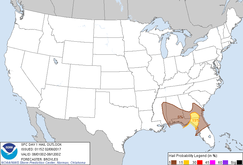
Probabilistic Damaging Wind Graphic
Probability of damaging thunderstorm winds or wind gusts of 50 knots or higher within 25 miles of a point. Hatched Area: 10% of greater probability of wind gusts 65 knots or greater within 25 miles of a point.
Day 1 Wind Risk
Area (sq. mi.)
Area Pop.
Some Larger Population Centers in Risk Area
15 %
14,032
707,694
Valdosta, GA...Tifton, GA...Waycross, GA...Lake City, FL...Douglas, GA...
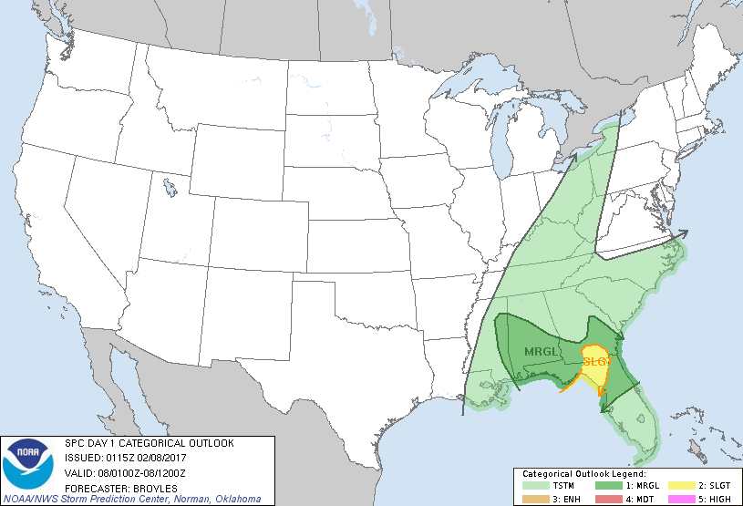
   SPC AC 080115

   Day 1 Convective Outlook CORR 1
   NWS Storm Prediction Center Norman OK
   0715 PM CST Tue Feb 07 2017

   Valid 080100Z - 081200Z

   ...THERE IS A SLIGHT RISK OF SEVERE THUNDERSTORMS ACROSS PARTS OF
   SOUTHERN GEORGIA AND NORTHERN FLORIDA...

   ...THERE IS A MARGINAL RISK OF SEVERE THUNDERSTORMS ACROSSS PARTS OF
   THE CENTRAL AND EASTERN GULF COAST STATES...

   CORRECTED FOR HAIL AND WIND GRAPHICS - ARROWS GOING WRONG DIRECTION

   ...SUMMARY...
   A severe threat will continue for a few more hours across parts of
   the central and eastern Gulf Coast States.

   ...Southern Georgia/Northern Florida...
   Latest radar imagery shows a bowing line segment from near Albany,
   Georgia extending southward to near Tallahassee, Florida. The 00Z
   soundings at Tallahassee appears to have sampled the airmass well
   just ahead of the line.  The sounding shows a surface dewpoint of 66
   F, SBCAPE of 1500 J/kg, 0-6 km shear of 45 Kts along with winds
   speeds increasingly sharply with height in the low-levels with 50
   knots of flow in the 800 to 850 mb layer.  This environment along
   with a 45 to 50 kt eastward motion should sustain the bowing line
   segment for a couple more hours. The stronger elements embedded in
   the line may be able to transfer the stronger low-level flow to the
   surface resulting in a wind damage threat. The wind damage threat
   should affect south central Georgia and northern Florida over the
   next couple hours. The line segment is expected to weaken
   substantially as it approaches Jacksonville, Florida later this
   evening.

   ...Eastern Mississippi/Southwestern Alabama...
   The latest radar imagery from Jackson, Mississippi shows a small
   cluster of thunderstorms to the southeast of Jackson near the
   Alabama state line. This cluster is located along an axis of
   moderate instability where MLCAPE values are estimated near 1500
   J/kg. In addition, the Jackson, Mississippi 00Z sounding shows
   strong deep-layer shear. This combined with 40 kts of flow at 850 mb
   will continue to support a marginal severe threat over the
   short-term but the convection is expected to continuing weakening as
   conditions become less favorable with time over the next hour or
   two.

   ..Broyles.. 02/08/2017

   CLICK TO GET WUUS01 PTSDY1 PRODUCT

   NOTE: THE NEXT DAY 1 OUTLOOK IS SCHEDULED BY 0600Z