New Orleans, LA...Baton Rouge, LA...Mobile, AL...Metairie, LA...Gulfport, MS...
MARGINAL
35,623
1,981,441
Lafayette, LA...Dothan, AL...Hattiesburg, MS...Panama City, FL...New Iberia, LA...
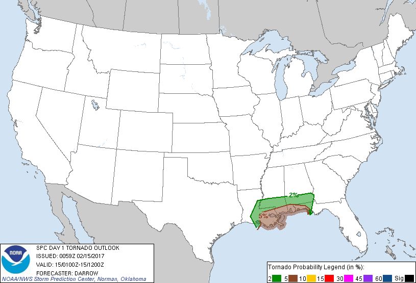
Probabilistic Tornado Graphic
Probability of a tornado within 25 miles of a point. Hatched Area: 10% or greater probability of EF2 - EF5 tornadoes within 25 miles of a point.
Day 1 Tornado Risk
Area (sq. mi.)
Area Pop.
Some Larger Population Centers in Risk Area
5 %
27,672
4,072,277
New Orleans, LA...Baton Rouge, LA...Mobile, AL...Metairie, LA...Gulfport, MS...
2 %
35,810
1,953,741
Lafayette, LA...Dothan, AL...Hattiesburg, MS...Panama City, FL...New Iberia, LA...
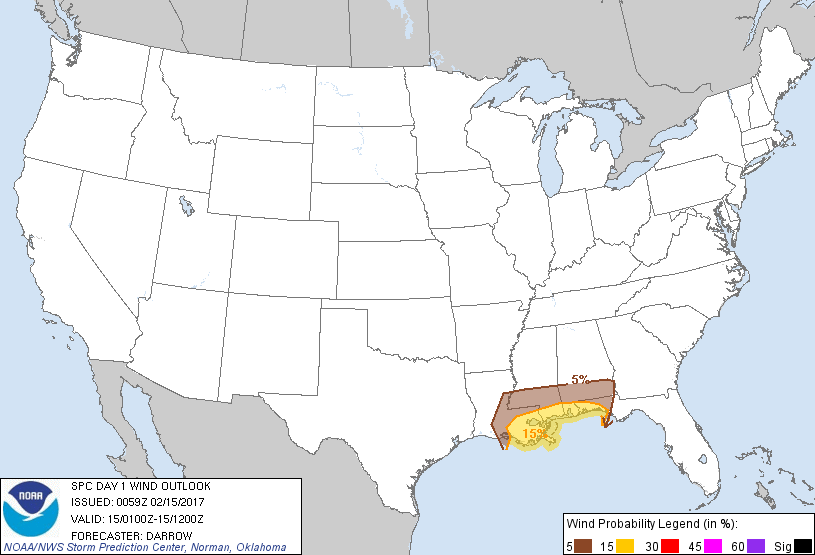
Probabilistic Damaging Wind Graphic
Probability of damaging thunderstorm winds or wind gusts of 50 knots or higher within 25 miles of a point. Hatched Area: 10% of greater probability of wind gusts 65 knots or greater within 25 miles of a point.
Day 1 Wind Risk
Area (sq. mi.)
Area Pop.
Some Larger Population Centers in Risk Area
15 %
26,996
4,016,577
New Orleans, LA...Baton Rouge, LA...Mobile, AL...Metairie, LA...Gulfport, MS...
5 %
36,856
2,034,736
Lafayette, LA...Dothan, AL...Hattiesburg, MS...Panama City, FL...New Iberia, LA...
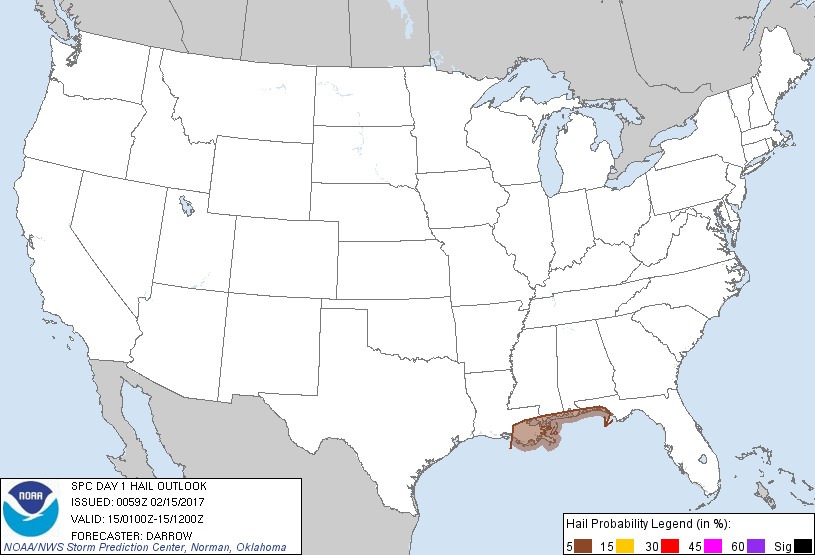
Probabilistic Large Hail Graphic
Probability of hail 1" or larger within 25 miles of a point. Hatched Area: 10% or greater probability of hail 2" or larger within 25 miles of a point.
Day 1 Hail Risk
Area (sq. mi.)
Area Pop.
Some Larger Population Centers in Risk Area
5 %
18,446
2,584,274
New Orleans, LA...Metairie, LA...Gulfport, MS...Kenner, LA...Pensacola, FL...
SPC AC 150059
Day 1 Convective Outlook
NWS Storm Prediction Center Norman OK
0659 PM CST Tue Feb 14 2017
Valid 150100Z - 151200Z
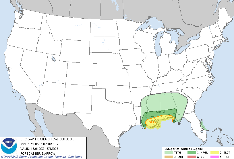
...THERE IS A SLIGHT RISK OF SEVERE THUNDERSTORMS ALONG THE CENTRAL
GULF COAST...
...THERE IS A MARGINAL RISK OF SEVERE THUNDERSTORMS ACROSS PARTS OF
THE GULF STATES...
...SUMMARY...
Isolated severe thunderstorms remain possible tonight across
southern Louisiana extending eastward along the Gulf coast.
...Gulf Coast...
Narrow, shallow band of near-surface based convection, with embedded
lightning, has developed along the cold front over LA. A narrow
wedge of modified Gulf air has returned northward across the lower
MS valley in the wake of stronger convection over the north central
Gulf. 00z soundings from this region do not sample this corridor of
somewhat higher instability that extends across south central LA
into southwest MS. Even so, buoyancy is not that great and aside
from an isolated severe wind gust it appears organized severe
thunderstorms may struggle to develop well inland ahead of expected
surface low track.
Farther south along the Gulf coast...southwest-northeast oriented
corridor of convection is shifting east along the LA coast. This
activity has temporarily impeded the northward advance of higher
theta-e air. However, large-scale forcing for ascent should
overspread this region later tonight as heights are suppressed and
deep-layer shear increases. Severe threat should increase near the
Gulf coast later tonight if sufficient buoyancy can develop for
robust sustained updrafts.
..Darrow.. 02/15/2017
CLICK TO GET WUUS01 PTSDY1 PRODUCT
NOTE: THE NEXT DAY 1 OUTLOOK IS SCHEDULED BY 0600Z