SPC AC 181934
Day 1 Convective Outlook
NWS Storm Prediction Center Norman OK
0134 PM CST Sat Feb 18 2017
Valid 182000Z - 191200Z
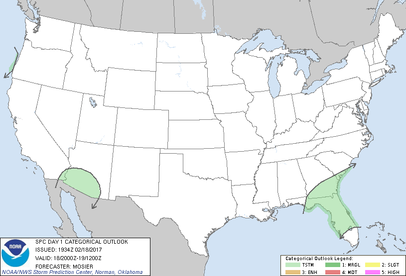
...NO SEVERE THUNDERSTORM AREAS FORECAST...
...SUMMARY...
While severe thunderstorms are not expected, isolated thunderstorms
will be possible in portions of the Southeast States as well as the
Desert Southwest.
...20Z Update...
Observational trends over the past few hours have shown a general
decrease in intensity with the line of storms approaching the
west-central FL peninsula. Continued displacement from the stronger
forcing for ascent and meager instability suggest this trend will
continue. Even so, some isolated lightning is still possible across
portions of the central FL peninsula. Farther north, isolated to
widely scattered thunderstorms remain possible across southern GA
and northern FL late this afternoon and evening as another shortwave
trough rounds the upper low centered over the middle MS valley.
Farther west, continued cooling aloft associated with the
eastward-progression upper trough will contribute to modest
destabilization with a few lightning strikes remaining possible.
Lastly, some isolated lightning is possible on the immediate central
OR coast as the main frontal band associated with an approaching
shortwave trough moves across the region.
..Mosier.. 02/18/2017
.PREV DISCUSSION... /ISSUED 1027 AM CST Sat Feb 18 2017/
...Florida...
An upper low currently centered over the lower Mississippi River
Valley/Mid-South region will continue generally eastward and reach
the southern Appalachians this evening. An ongoing quasi-linear
convective cluster over the eastern Gulf of Mexico will continue to
move toward the western Florida peninsula today before likely
weakening. While modest low-level moistening will continue to occur
across parts of the peninsula, richer maritime air will generally
remain confined to south Florida. Cloud cover will otherwise likely
persist over the peninsula much of the afternoon via the ongoing
convection. While a strong storm or two could approach the western
peninsula, organized severe storms appear unlikely, mainly given the
limited moisture/buoyancy over inland areas.
CLICK TO GET WUUS01 PTSDY1 PRODUCT
NOTE: THE NEXT DAY 1 OUTLOOK IS SCHEDULED BY 0100Z
|