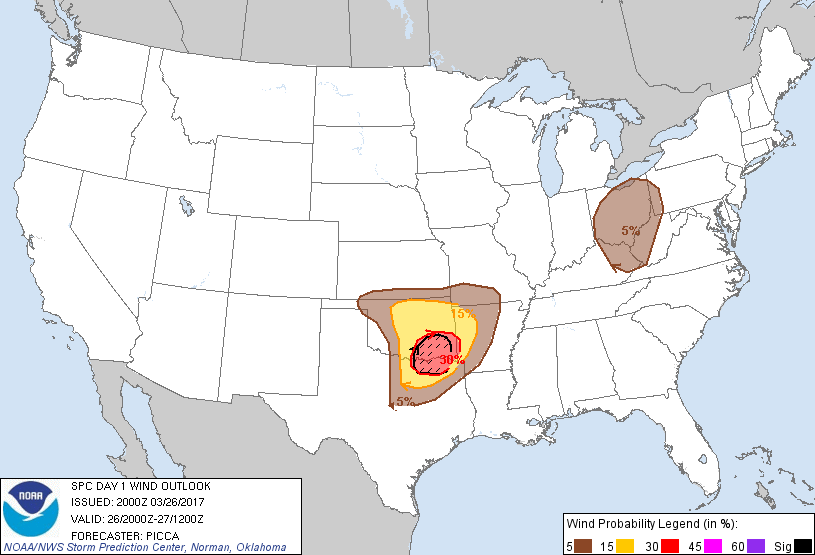
Probability of damaging thunderstorm winds or wind gusts of 50 knots or higher within 25 miles of a point. Hatched Area: 10% of greater probability of wind gusts 65 knots or greater within 25 miles of a point.
Wichita, KS...Springfield, MO...Waco, TX...Killeen, TX...Wichita Falls, TX...
SPC AC 262000
Day 1 Convective Outlook
NWS Storm Prediction Center Norman OK
0300 PM CDT Sun Mar 26 2017
Valid 262000Z - 271200Z
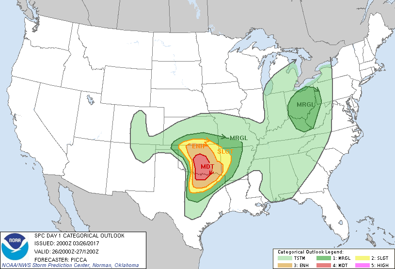
...THERE IS A MODERATE RISK OF SEVERE THUNDERSTORMS ACROSS CENTRAL
OK AND FAR NORTH-CENTRAL TX...
...THERE IS AN ENHANCED RISK OF SEVERE THUNDERSTORMS ACROSS
CENTRAL/EASTERN OK AND NORTH TX...
...THERE IS A SLIGHT RISK OF SEVERE THUNDERSTORMS ACROSS PORTIONS OF
THE SOUTHERN PLAINS...
...THERE IS A MARGINAL RISK OF SEVERE THUNDERSTORMS FROM CENTRAL TX
TO THE OZARKS...
...THERE IS A MARGINAL RISK OF SEVERE THUNDERSTORMS ACROSS THE UPPER
OH VALLEY...
...SUMMARY...
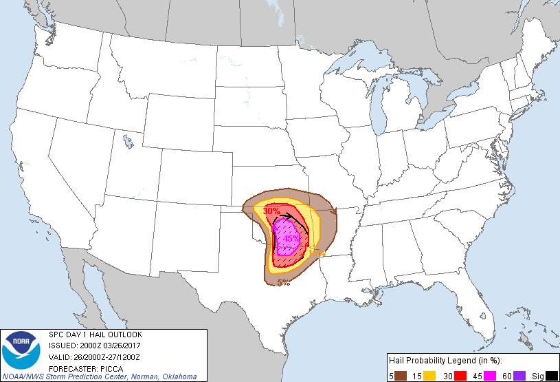
Numerous severe storms with very large hail, tornadoes, and damaging
winds are expected after 4 pm CDT especially across central and
eastern Oklahoma and north Texas through evening.
...Discussion...
The overall forecast philosophy remains relatively unchanged, with
an expectation for severe thunderstorms to rapidly develop late this
afternoon along a dryline across central Oklahoma southward into
north Texas. Initial elevated convection that developed over central
Oklahoma early this afternoon continues to advance east/northeast in
tandem with a low-level jet. These cells may continue to briefly
pose a marginally severe hail threat, but are expected to weaken
with northeastward extent.
Farther southwest, despite pockets of stronger mixing, dew points in
the mid/upper 50s to lower 60s have streamed north ahead of the
dryline, resulting in MLCAPE values around 1000-1500 J/kg across far
southern Oklahoma and north Texas. As stronger large-scale ascent
continues to overspread this corridor, storms should expand in
coverage, with supercell modes capable of all very large hail,
damaging winds, and a few tornadoes. The most notable change with
this outlook is the expansion of higher hail and tornado
probabilities southward across north Texas. Recent visible satellite
imagery and hi-res guidance suggest a relative maximum in severe
potential near and perhaps just south of the Red River. Cells
developing to the west/southwest should mature as they enter this
corridor of relatively greater low-level moisture. For more
information on the threat, reference Mesoscale Discussion 335.
..Picca.. 03/26/2017
.PREV DISCUSSION... /ISSUED 1130 AM CDT Sun Mar 26 2017/
...Southern Plains...
Embedded within a moderately strong belt of southern-stream
westerlies, a relatively compact shortwave trough over the
south-central High Plains at late morning will continue eastward and
reach the Ozarks by late tonight. Within the base of this trough,
12Z upper-air analysis featured a 50 kt belt of mid/high-level (500
mb and above) southwesterly winds that extend from southern/eastern
NM into the TX panhandle/far western OK/southwest KS. Given that
less that 48 hours has passed since the prior system (now over the
Midwest) at this general latitude/longitude, moisture
return/availability across the southern Plains remains a point of
uncertainty, especially regarding the magnitude of the tornado risk
in an otherwise very favorable early-Spring Southern Plains setup.
Beneath an eastward-advecting elevated mixed plume (sampled across
the south-central High Plains at 12Z), surface observations feature
around 60F dewpoints into southern parts of DFW Metroplex as of 16Z.
These near-60F dewpoints should reach parts of south-central OK by
21Z-00Z. Visible satellite imagery shows a band of higher-level
cloud cover that will overspread the increasingly moist warm sector
this afternoon. While not typically a severe-favorable factor, this
cloud cover should at least partially shield the boundary layer and
somewhat deter mixing while otherwise supporting a gradual increase
in near-surface moisture through the afternoon/early evening.
Current trends/short-term guidance suggest this cirrus should
overspread/progress east of the dryline toward/after roughly 21Z.
Ahead of the slow-eastward-mixing dryline, near-60F surface
dewpoints should generally result in around 1500-2000 J/kg of MLCAPE
by peak heating from south-central OK into western parts of North
TX. Weaker near-surface destabilization is expected farther north
into northwest/north-central OK and extreme southern KS.
As forcing for ascent and deep-layer shear (effectively 40+ kt)
increase, late-morning thinking is that semi-discrete supercells
will begin to develop by mid-afternoon (around 21Z/4PM CDT) across
west-central OK into western north TX, initiating just west of the
I-35 corridor. Potentially very large hail is likely along with at
least some tornado risk, which should at least somewhat increase
through 23Z-01Z toward/east of the I-35 corridor, especially across
south-central OK and far north TX as low-level moisture continually
increases and low-level hodographs enlarge.
Sustained warm advection should contribute to an eventual clustering
and bowing of storms by late evening as storms persist generally
eastward especially across southeast OK and extreme northeast TX.
Accordingly, damaging wind potential may increase for a time late
this evening before updraft/downdraft intensities wane overnight as
storms progress into AR/ArkLaTex vicinity.
...Upper Ohio River Valley...
A shortwave trough centered over northern/central IL late this
morning per water vapor satellite imagery will continue
east/northeastward today, with a weakening/opening trend expected
tonight. Moderately strong winds aloft (12Z upper-air data and more
contemporary WSR-88D vwp data) just ahead of this trough will
overspread the upper Ohio River Valley vicinity through the
afternoon/evening. Modest moisture (lower to middle 50s F surface
dewpoints aside), prevalent cloud cover and multiple ongoing bands
of showers suggest that overall destabilization should remain
limited. Even so, locally damaging winds, marginally severe hail and
possibly a brief tornado could occur presuming at least modest
diurnal destabilization. Parts of southern OH, northeast KY into
western/northern WV currently appear most susceptible to a
severe-storm risk this afternoon/early evening.
CLICK TO GET WUUS01 PTSDY1 PRODUCT
NOTE: THE NEXT DAY 1 OUTLOOK IS SCHEDULED BY 0100Z