New Orleans, LA...Tulsa, OK...Baton Rouge, LA...Montgomery, AL...Jackson, MS...
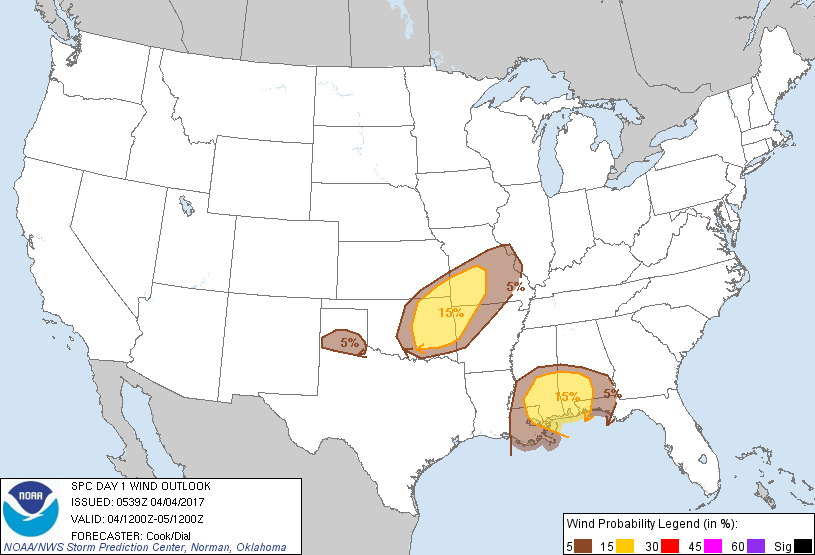
Probabilistic Damaging Wind Graphic
Probability of damaging thunderstorm winds or wind gusts of 50 knots or higher within 25 miles of a point. Hatched Area: 10% of greater probability of wind gusts 65 knots or greater within 25 miles of a point.
Oklahoma City, OK...Kansas City, MO...New Orleans, LA...Wichita, KS...Baton Rouge, LA...
SPC AC 040539
Day 1 Convective Outlook
NWS Storm Prediction Center Norman OK
1239 AM CDT Tue Apr 04 2017
Valid 041200Z - 051200Z
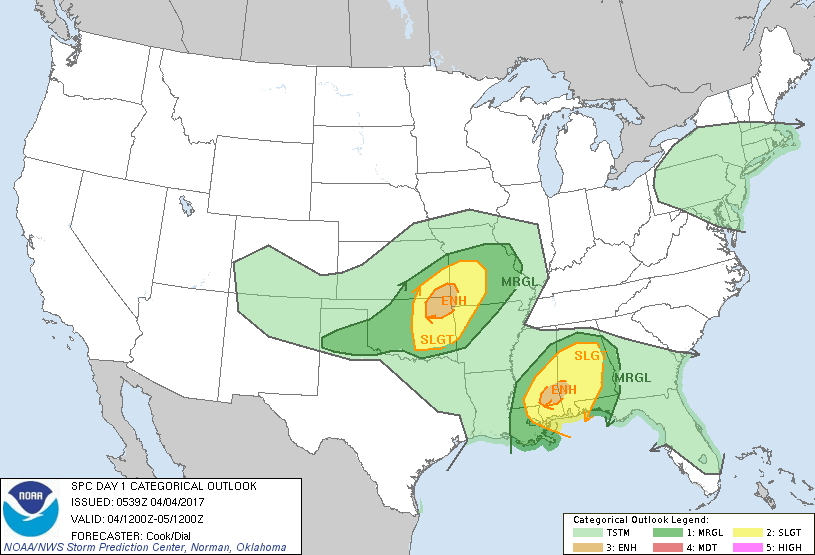
...THERE IS AN ENHANCED RISK OF SEVERE THUNDERSTORMS IN PORTIONS OF
NORTHEASTERN OKLAHOMA...SOUTHEASTERN KANSAS...AND FAR SOUTHWESTERN
MISSOURI...
...THERE IS AN ENHANCED RISK OF SEVERE THUNDERSTORMS IN PORTIONS OF
SOUTHEASTERN MISSISSIPPI AND SOUTHWESTERN ALABAMA...
...THERE IS A SLIGHT RISK OF SEVERE THUNDERSTORMS FROM PORTIONS OF
OKLAHOMA NORTHEASTWARD INTO CENTRAL MISSOURI...
...THERE IS A SLIGHT RISK OF SEVERE THUNDERSTORMS IN PORTIONS OF THE
GULF COAST STATES...
...THERE IS A MARGINAL RISK OF SEVERE THUNDERSTORMS FROM MUCH OF
OKLAHOMA NORTHEASTERN TO FAR WESTERN ILLINOIS...
...THERE IS A MARGINAL RISK OF SEVERE THUNDERSTORMS ACROSS PORTIONS
OF THE GULF COAST REGION AND DEEP SOUTH...
...SUMMARY...
Scattered strong to severe thunderstorms will be possible across
parts of the south-central Plains into the Ozarks this afternoon and
early evening, and across parts of the central Gulf Coast states
late tonight into early Wednesday morning.
...Synopsis...
A vigorous mid/upper trough and attendant powerful jet over the
Intermountain West will migrate eastward over the central Plains in
the afternoon and evening. As this occurs, southwesterly mid-level
flow will strengthen across portions of the southern Plains and
eventually the lower- and mid-Mississippi Valley regions. At the
surface, a low - initially over western north Texas - will deepen
some while migrating northeastward across central Oklahoma and into
southwestern Missouri by the end of the period. Late in the period,
a warm front along the Gulf Coast will migrate inland to portions of
central Mississippi and Alabama by the end of the period.
...Portions of the southern Plains and adjacent Ozarks...
Strengthening flow aloft will commence with the approach of the
mid-level disturbance. Forcing for ascent associated with the
approaching trough, convergence along the nose of a 30-40 kt
low-level jet nearly perpendicular to a stationary surface boundary
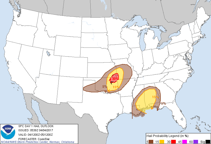
over Oklahoma, and steep mid-level lapse rates will all foster the
development of scattered thunderstorms perhaps as early as late
morning. Elevated thunderstorms north of the surface boundary
should foster mostly a severe hail risk. Storms developing on the
warm side of this boundary should have relatively high bases (owing
to modest moisture return and low to mid-50s F dewpoints), although
very steep low- and mid-level lapse rates should foster a hail and
wind threat with this activity. Activity should eventually
consolidate into a line or linear segments that will move
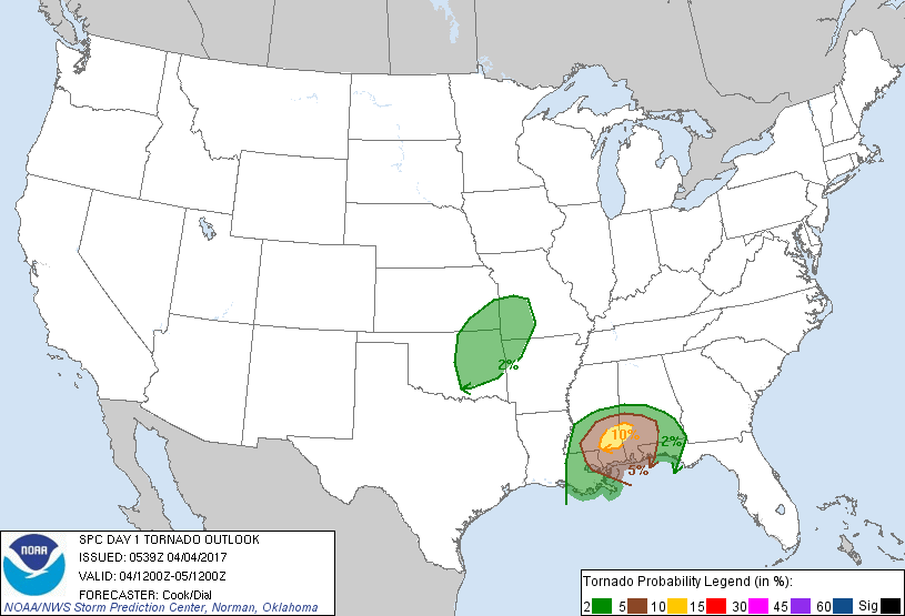
northeastward, with a continued hail/wind and isolated tornado
threat into the overnight. This line, although in a weakened state,
may reach portions of western Illinois by the end of the forecast
period.
...Southeastern Louisiana, southern and eastern Mississippi, much of
Alabama, western Georgia, and the Florida Panhandle...
Low-level warm advection in response to the Plains mid-level
disturbance will foster northward retreat of a stationary front
currently across the central/northeastern Gulf of Mexico. This
eventual warm front will migrate inland late in the period, with low
70s dewpoints fostering moderate instability in portions of the
region amidst a weakly capped, yet strongly sheared airmass. Subtle
height falls associated with the approaching mid-level disturbance,
broad warm-sector confluence, and convergence along the warm front
will foster the development of a few thunderstorms overnight in
southeastern Louisiana spreading northeastward toward the end of the
forecast period. All modes of severe are possible with this
activity, along with potential for a few tornadoes especially in the
'enhanced' risk area across southeast Mississippi and southwest
Alabama. Farther northeast, elevated thunderstorms will foster a
hail risk in portions of central Alabama toward 12Z.
..Cook/Dial.. 04/04/2017
CLICK TO GET WUUS01 PTSDY1 PRODUCT
NOTE: THE NEXT DAY 1 OUTLOOK IS SCHEDULED BY 1300Z