New Orleans, LA...Tulsa, OK...Baton Rouge, LA...Montgomery, AL...Jackson, MS...
Probabilistic Damaging Wind Graphic
Probability of damaging thunderstorm winds or wind gusts of 50 knots or higher within 25 miles of a point. Hatched Area: 10% of greater probability of wind gusts 65 knots or greater within 25 miles of a point.
Philadelphia, PA...Oklahoma City, OK...New Orleans, LA...Atlanta, GA...Newark, NJ...
SPC AC 041249
Day 1 Convective Outlook
NWS Storm Prediction Center Norman OK
0749 AM CDT Tue Apr 04 2017
Valid 041300Z - 051200Z
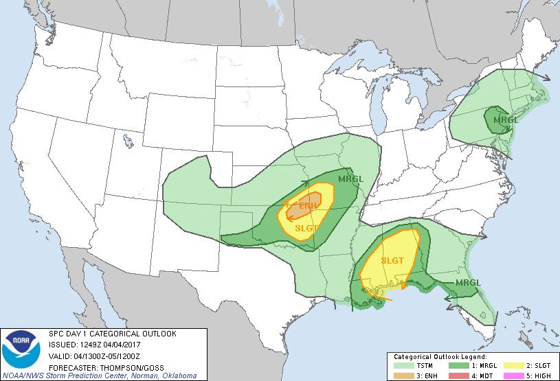
...THERE IS AN ENHANCED RISK OF SEVERE THUNDERSTORMS THIS
AFTERNOON/EVENING FROM NORTHEAST OKLAHOMA INTO SOUTHWEST MISSOURI...
...THERE IS A SLIGHT RISK OF SEVERE THUNDERSTORMS THIS AFTERNOON
INTO TONIGHT FROM CENTRAL/EASTERN OKLAHOMA TO NORTHWESTERN ARKANSAS
AND CENTRAL MISSOURI...
...THERE IS A SLIGHT RISK OF SEVERE THUNDERSTORMS LATE TONIGHT
ACROSS PARTS OF THE NORTH CENTRAL/NORTHEAST GULF COAST...
...THERE IS A MARGINAL RISK OF SEVERE THUNDERSTORMS SURROUNDING THE
PLAINS/OZARKS SLIGHT RISK...
...THERE IS A MARGINAL RISK OF SEVERE THUNDERSTORMS ACROSS NORTH
FLORIDA TODAY...AND FROM SOUTHEAST LOUISIANA AND NORTHERN
ALABAMA/NORTHWESTERN GEORGIA LATE TONIGHT...
...THERE IS A MARGINAL RISK OF SEVERE THUNDERSTORMS THIS AFTERNOON
ACROSS EASTERN PENNSYLVANIA AND VICINITY...
...SUMMARY...
Scattered strong to severe thunderstorms will be possible across
parts of the south-central Plains into the Ozarks this afternoon and
early evening, and across parts of the central Gulf Coast states
late tonight into early Wednesday morning. Isolated strong storms
will also be possible today across part of north Florida and in the
vicinity of eastern Pennsylvania.
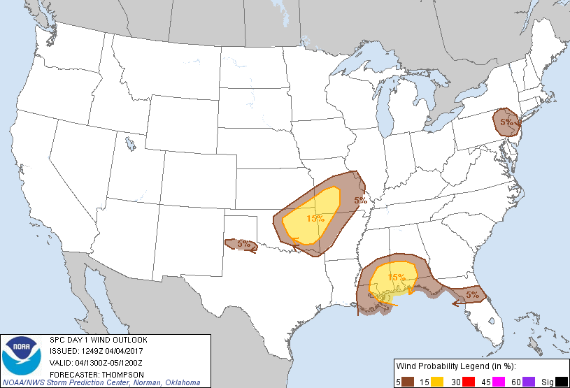
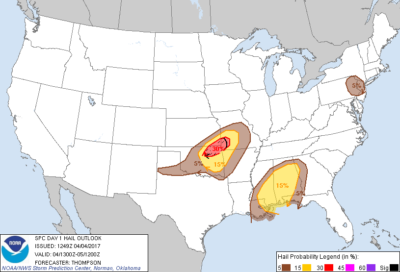
...I-44 corridor from northeast OK into MO this evening...
A compact midlevel shortwave trough over northern NM this morning
will progress eastward to central OK this evening and the Ozarks
overnight. An associated surface cyclone initially in northwest TX
will develop northeastward along a stalled front near I-44 in OK, in
advance of the midlevel trough. Strengthening wind profiles and
ascent will immediate precede the midlevel trough and surface
cyclone and support strong-severe thunderstorm development this
afternoon in OK, and the storms will spread into MO/AR overnight.
The primary limiting factor to a more robust severe-weather risk
will be marginal moisture return in the warm sector of the cyclone.
The maritime tropical air mass was shunted southward into the north
central and northwest Gulf of Mexico by the system the prior two
days. Residual boundary layer dewpoints in the low-mid 50s, aided
some today by evapotranspiration but offset by vertical mixing, are
expected up to the stalled front from central OK into southwest MO
by mid-late afternoon. This moisture, along with afternoon surface
temperatures in the 70s and midlevel lapse rates of 8 C/km or
greater, will drive MLCAPE of 1000-1500 J/kg. This buoyancy,
combined with effective bulk shear in excess of 50 kt, and
relatively cool midlevel temperatures, will support a risk for
supercells with large hail near and just ahead of the surface
cyclone/triple point in beginning 21-23z in OK and continuing into
MO through late evening. Storms may also develop southward along
the cold front into eastern OK and northwestern AR, though the
strongest/most persistent storms are expected along the path of the
cyclone along the I-44 corridor from northeast OK into southwest MO
through early tonight.
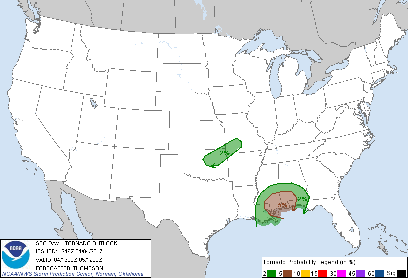
The tornado risk is limited mostly by the marginal low-level
moisture. There might be a narrow zone along the stalled front
(immediately ahead of the surface cyclone) where moisture will be
sheltered some from vertical mixing, and where low-level hodographs
will by the largest with the most streamwise vorticity. A discrete
storm moving along this narrow zone could produce a tornado before
near-surface cooling/stabilization ends the threat just after
sunset.
...North central Gulf coast into Dixie early Wednesday...
In response to cyclogenesis with the shortwave trough approaching
the Ozarks, the maritime tropical air mass will return northward
late tonight and early Wednesday in a strengthening warm advection
regime. Elevated thunderstorm development is expected from 06-12z
from southeast LA into at least central AL. Large hail will be the
main risk early Wednesday across the northern parts of the Slight
Risk area. Farther south near the surface warm front, some of the
convection could become rooted near or at the surface. Deep-layer
and low-level shear will favor supercells, and profiles will become
supportive of some tornado and/or damaging wind risk from 09-12z.
The main uncertainties will be the specific corridor of storm
development and the narrow time window for surface-based storms.
Thus, 5% tornado probabilities appear most appropriate within this
outlook period.
...North FL today...
A lingering band of storms along a composite outflow boundary will
sag southward through the day across north FL. Isolated strong
gusts will be possible the first half of the day within this band,
before the convection weakens.
...Eastern PA and vicinity this afternoon...
A midlevel trough and an associated/diffuse surface trough will
cross PA during the day. Lingering low-level moisture and some
surface heating will contribute to weak surface-based instability
across this area by midday/early afternoon, and will be sufficient
for at least isolated thunderstorm development. Given somewhat cool
midlevel temperatures and effective bulk shear of 30-40 kt, a
low-end hail/wind risk will be possible this afternoon with the
stronger/more organized cells.
..Thompson/Goss.. 04/04/2017
CLICK TO GET WUUS01 PTSDY1 PRODUCT
NOTE: THE NEXT DAY 1 OUTLOOK IS SCHEDULED BY 1630Z