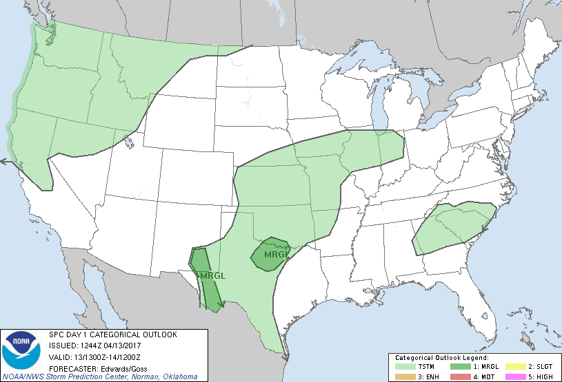
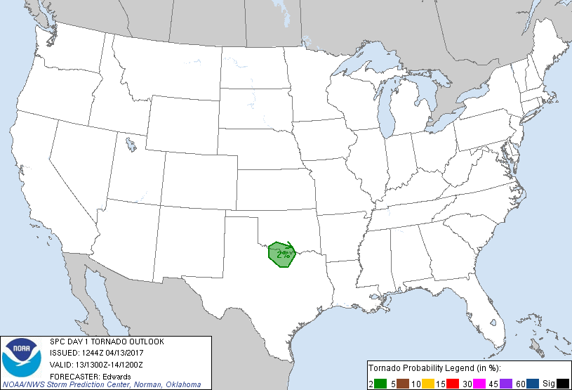
Wichita Falls, TX...Denton, TX...Lawton, OK...Roswell, NM...Carlsbad, NM...
Probabilistic Tornado Graphic
Probability of a tornado within 25 miles of a point. Hatched Area: 10% or greater probability of EF2 - EF5 tornadoes within 25 miles of a point.
Day 1 Tornado Risk
Area (sq. mi.)
Area Pop.
Some Larger Population Centers in Risk Area
2 %
12,584
798,917
Wichita Falls, TX...Denton, TX...Lawton, OK...Ardmore, OK...Duncan, OK...
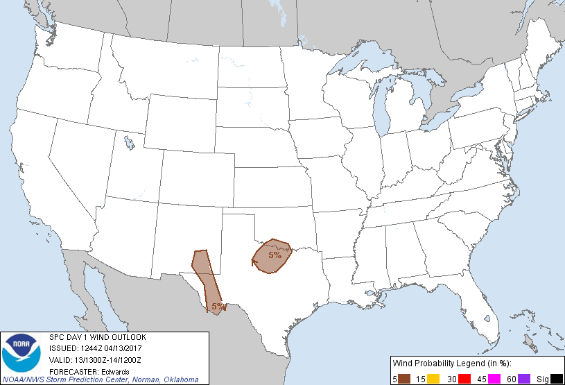
Probabilistic Damaging Wind Graphic
Probability of damaging thunderstorm winds or wind gusts of 50 knots or higher within 25 miles of a point. Hatched Area: 10% of greater probability of wind gusts 65 knots or greater within 25 miles of a point.
Day 1 Wind Risk
Area (sq. mi.)
Area Pop.
Some Larger Population Centers in Risk Area
5 %
47,587
1,244,090
Abilene, TX...Wichita Falls, TX...Denton, TX...Lawton, OK...Roswell, NM...
Probabilistic Large Hail Graphic
Probability of hail 1" or larger within 25 miles of a point. Hatched Area: 10% or greater probability of hail 2" or larger within 25 miles of a point.
Day 1 Hail Risk
Area (sq. mi.)
Area Pop.
Some Larger Population Centers in Risk Area
5 %
47,587
1,244,090
Abilene, TX...Wichita Falls, TX...Denton, TX...Lawton, OK...Roswell, NM...
   SPC AC 131244

   Day 1 Convective Outlook
   NWS Storm Prediction Center Norman OK
   0744 AM CDT Thu Apr 13 2017

   Valid 131300Z - 141200Z

   ...THERE IS A MARGINAL RISK OF SEVERE THUNDERSTORMS OVER PARTS OF
   NORTHWEST/NORTH-CENTRAL TEXAS AND SOUTHERN OKLAHOMA...

   ...THERE IS A MARGINAL RISK OF SEVERE THUNDERSTORMS NEAR THE HIGHER
   TERRAIN OF SOUTHEASTERN NEW MEXICO AND WEST TEXAS...

   ...SUMMARY...
   Isolated large hail and gusty winds are possible this afternoon and
   early evening over portions of northwest and north-central Texas to
   southern Oklahoma, and from southeastern New Mexico to parts of west
   Texas.

   ...Synopsis...
   In mid/upper levels, higher amplitude is expected to the pattern
   than in previous days, with synoptic-scale troughing generally
   extending equatorward from major cyclones located over Baffin and
   Vancouver islands.  In between, mean ridging will prevail over the
   Plains states northwestward across western Canada.  A strong/basal
   shortwave trough -- now evident in moisture-channel imagery near the
   CA coast -- will move east-northeastward to northeastward across the
   interior Pacific Northwest and northern Great Basin through the
   period, in support of general thunderstorm potential from the
   Pacific coast to the northern Rockies.  Farther southeast, a
   southern-stream perturbation is evident over eastern NM and far west
   TX, with an intermittently closed 500-mb low over northeastern NM.
   Separate, smaller-scale vorticity maxima (likely MCVs) were evident
   in reflectivity animations over portions of the southeastern TX
   Panhandle and northwest TX, and will move slowly northeastward ahead
   of the main trough today.  By 00Z the latter should extend from
   western KS to west-central TX, ejecting northeastward through the
   mean ridge and over the central Plains overnight.

   At the surface, lee cyclogenesis is expected by 00Z over
   central/north-central MT with troughing southeastward over eastern
   portions of CO/NM.  Otherwise, the surface pattern in and near the
   outlook areas will be dominated by mesoscale and convectively
   modulated features.

   ...Northwest/north-central TX to southern OK...
   Episodic swaths of precip with embedded thunderstorms -- mainly
   non-severe -- are expected to move northeastward across parts of
   west-central/northwest TX and western OK through the period.
   Activity mostly will occur in an environment characterized by
   marginal theta-e in low levels (resulting from trajectories out of
   an antecedent, partly moistened continental air mass and/or precip
   areas) and weak midlevel lapse rates.

   However, this afternoon into early evening, and in a relatively
   small/mesoscale area on the southeast rim of the regime, conditions
   may favor severe thunderstorms with transient supercell character
   possible.  Pockets of surface heating should steepen low-level lapse
   rates amidst 60s F surface dew points, yielding around 1000-1500
   J/kg MLCAPE.  This field of buoyancy may overlap southern portions
   of an enhanced midlevel flow field related to height perturbation by
   the trough, with effective-shear magnitudes potentially reaching
   30-40 kt. Mesoscale LLJ development/enhancement from late afternoon
   into early evening also may boost hodograph sizes and SRH near the
   Red River, arranging a supportive environment for any relatively
   discrete storms to rotate before they encounter unfavorable buoyancy
   and/or other precip/convection.  Limiting factors include lack of
   larger lapse rates/CAPE, indefinite boundaries to focus lift, and
   potentially messy storm modes.

   ...Southeastern NM, west TX...
   Isolated to widely scattered thunderstorms should form this
   afternoon over the higher terrain in the western part of the outlook
   area, such as the Chisos, Davis, and Guadalupe Mountains.  With
   departure of the mid/upper-level trough, upper support will be
   minimal at best (helping to limit coverage).  A few factors will
   support strong to briefly severe thunderstorms with localized hail
   and gusts being the concerns:
   1.  Strong surface heating of higher terrain,
   2.  Steep midlevel lapse rates,
   3.  Pockets of weak upslope flow and related lift, and
   4.  Residual but adequate boundary-layer moisture in the wake of
   yesterday's MCS, with PW ranging from around an inch in the Big bend
   region to less than half an inch on the northern fringes.
   MLCAPE 1000-1500 J/kg (locally near 2000 J/kg) will support this
   potential, though weak low/middle-level flow will keep shear
   minimized and storm motions slow.

   ..Edwards/Goss.. 04/13/2017

   CLICK TO GET WUUS01 PTSDY1 PRODUCT

   NOTE: THE NEXT DAY 1 OUTLOOK IS SCHEDULED BY 1630Z