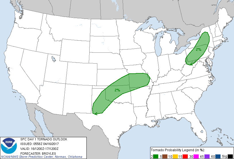
Probability of a tornado within 25 miles of a point. Hatched Area: 10% or greater probability of EF2 - EF5 tornadoes within 25 miles of a point.
Day 1 Tornado Risk
Area (sq. mi.)
Area Pop.
Some Larger Population Centers in Risk Area
2 %
199,771
17,220,962
Oklahoma City, OK...Tulsa, OK...Wichita, KS...Pittsburgh, PA...Lubbock, TX...
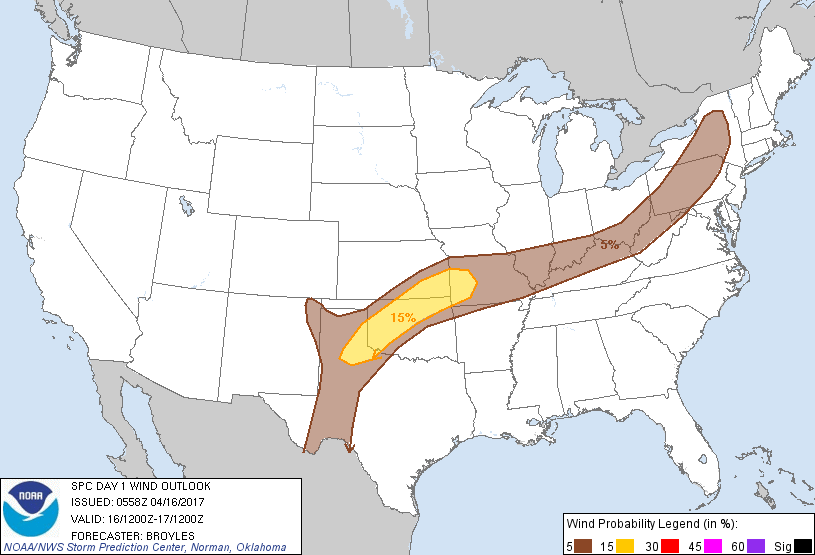
Probabilistic Damaging Wind Graphic
Probability of damaging thunderstorm winds or wind gusts of 50 knots or higher within 25 miles of a point. Hatched Area: 10% of greater probability of wind gusts 65 knots or greater within 25 miles of a point.
Day 1 Wind Risk
Area (sq. mi.)
Area Pop.
Some Larger Population Centers in Risk Area
15 %
61,011
2,898,365
Oklahoma City, OK...Tulsa, OK...Springfield, MO...Edmond, OK...Midwest City, OK...
SPC AC 160558
Day 1 Convective Outlook
NWS Storm Prediction Center Norman OK
1258 AM CDT Sun Apr 16 2017
Valid 161200Z - 171200Z
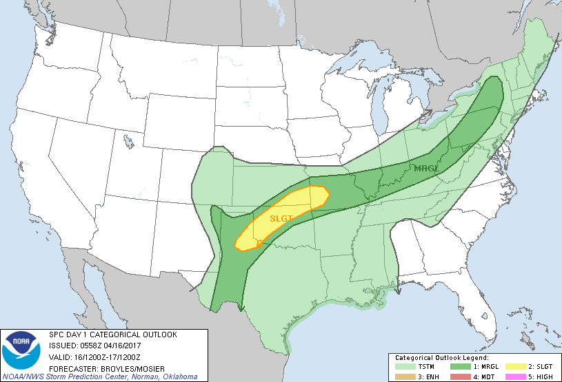
...THERE IS A SLIGHT RISK OF SEVERE THUNDERSTORMS ACROSS PARTS OF
THE SOUTHERN AND CENTRAL PLAINS...
...THERE IS A MARGINAL RISK OF SEVERE THUNDERSTORMS OUTSIDE OF THE
SLIGHT RISK AREA FROM PARTS OF THE SOUTHERN PLAINS NORTHEASTWARD
INTO THE MID MISSISSIPPI VALLEY...OHIO VALLEY AND CENTRAL TO
NORTHERN APPALACHIANS...
...SUMMARY...
Isolated to scattered severe thunderstorms with a potential for
large hail and wind damage are possible today across parts of the
southern Plains into the northern Ozarks. Marginally severe
thunderstorms with strong wind gusts and hail are also possible from
the Ohio Valley into the central and northern Appalachians.
....Southern and Central Plains/Northern Ozarks...
West southwest mid-level flow will be in place today across the
southern Plains. At the surface, a cold front will move slowly
southward across the Texas Panhandle, northern Oklahoma and western
Missouri. A moist airmass will be in place south of the front with
surface dewpoints in the mid 60s F. As surface heating takes place
across the warm sector today, moderate to strong instability is
expected to develop ahead of the front from the southern Plains into
the northern Ozarks. This along with increasing low-level
convergence along the boundary should result in the initiation of
scattered thunderstorms during the mid to late afternoon from the
southeast Texas Panhandle northeastward across western and northern
Oklahoma into southwest Missouri. Forecast soundings along this
corridor at 00Z/Monday show MLCAPE values in the 2000 to 3000 J/Kg
range along with steep mid-level lapse rates. This along with 30 to
35 kt of 0-6 km shear should be enough for rotating cells and
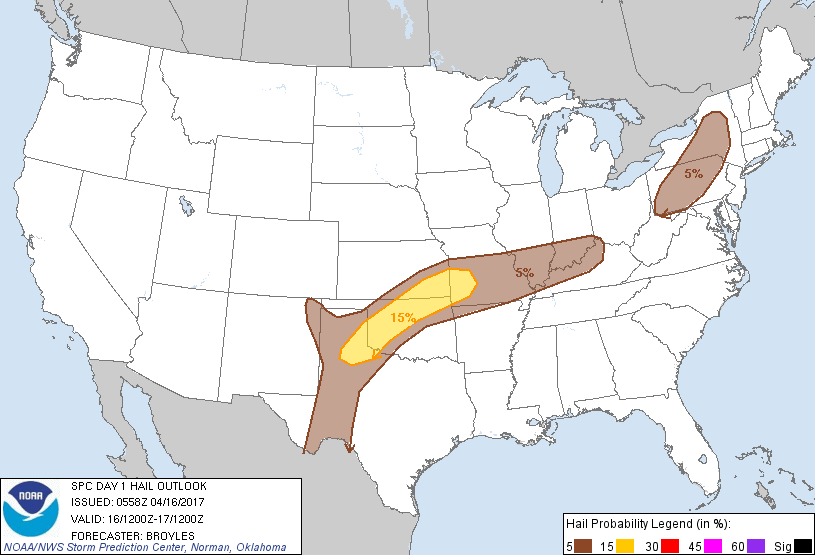
organized line segments. Supercells with large hail and wind damage
will be possible across parts of the southern Plains along the axis
of strongest instability. Wind damage may also occur with short
multicell line segments. The current thinking is that several small
clusters of strong to severe thunderstorms will move southeastward
across the slight risk area during the late afternoon and early
evening. Isolated strong to severe thunderstorms will also be
possible to the east of a surface trough in west Texas but limited
large-scale ascent should help to keep any severe threat marginal
there.
...Central and Northern Appalachians/Ohio Valley/Mid Mississippi
Valley...
Westerly mid-level flow will be in place across the Ohio Valley and
lower Great Lakes region today. At the surface, a cold front will
advance eastward across the region today with a narrow corridor of
low-level moisture in place just ahead of the front. Surface
dewpoints should range from the mid 50s F in the central Appalachian
mountains to the lower 60s F in the Ohio Valley. As surface heating
takes place, weak instability is forecast to develop along the
front. This combined with increasing low-level convergence should
result in thunderstorm development by midday from eastern Ohio
northeastward into northwest Pennsylvania and western New York. This
convection is forecast to organize into a line and move eastward
across central New York and western Pennsylvania during the early to
mid afternoon. Forecast soundings along this corridor at 21Z show
unidirectional wind profiles above 850 mb along with strong speed
shear in the low to mid-levels. This along with steep low-level
lapse rates should result in an isolated wind damage threat with
hail also possible. The threat should remain marginal due to weak
instability.
Further southwest across the mid Mississippi Valley and lower Ohio
Valley, scattered thunderstorm development is forecast to occur
along and ahead of the front this afternoon. Although pockets of
moderate instability may develop along this corridor, forecast
soundings suggest 0-6 km shear will remain mostly below 30 kt. This
should marginalize any severe threat with isolated damaging wind
gusts and hail as the primary hazards.
..Broyles/Mosier.. 04/16/2017
CLICK TO GET WUUS01 PTSDY1 PRODUCT
NOTE: THE NEXT DAY 1 OUTLOOK IS SCHEDULED BY 1300Z