Probability of damaging thunderstorm winds or wind gusts of 50 knots or higher within 25 miles of a point. Hatched Area: 10% of greater probability of wind gusts 65 knots or greater within 25 miles of a point.
Day 1 Wind Risk
Area (sq. mi.)
Area Pop.
Some Larger Population Centers in Risk Area
5 %
87,427
2,206,701
Corpus Christi, TX...Laredo, TX...Brownsville, TX...Harlingen, TX...Mission, TX...
Probabilistic Large Hail Graphic
Probability of hail 1" or larger within 25 miles of a point. Hatched Area: 10% or greater probability of hail 2" or larger within 25 miles of a point.
Day 1 Hail Risk
Area (sq. mi.)
Area Pop.
Some Larger Population Centers in Risk Area
5 %
103,642
2,250,330
Corpus Christi, TX...Laredo, TX...Brownsville, TX...Harlingen, TX...Mission, TX...
SPC AC 171251
Day 1 Convective Outlook
NWS Storm Prediction Center Norman OK
0751 AM CDT Mon Apr 17 2017
Valid 171300Z - 181200Z
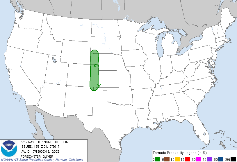
...THERE IS A MARGINAL RISK OF SEVERE THUNDERSTORMS ACROSS THE HIGH
PLAINS...
...THERE IS A MARGINAL RISK OF SEVERE THUNDERSTORMS ACROSS DEEP
SOUTH TEXAS...
...SUMMARY...
Very isolated severe thunderstorms with hail and strong wind gusts
are expected across parts of the High Plains and south Texas mainly
this afternoon and evening.
...High Plains...
A shortwave trough over OR/ID early this morning will continue
eastward and reach the Dakotas late tonight. A related belt of
strengthening mid-level westerly winds will overspread a sharpening
lee trough across the north-central High Plains and Black Hills
vicinity. While the boundary layer will not be moist (40s to near
50F surface dewpoints) near and east of the north-central High
Plains lee trough, relatively cool temperatures aloft and steep
mid-level lapse rates may support as much as 750 J/kg MLCAPE by peak
heating. Current thinking is that a couple of sub-regional corridors
of isolated thunderstorm development will occur from the Black Hills
vicinity southward into northeast Colorado by late afternoon.
Adequate moisture/buoyancy and 40+ kt of shear could support a few
supercells capable of large hail and strong downdrafts.
Farther south, other isolated severe thunderstorms will be possible
this afternoon across southeast CO/northeast NM and the Raton Mesa
vicinity with aid of a lee-side trough and low-level upslope
trajectories. Steep lapse rates, moderate buoyancy, and around 30-35
kt of effective shear would conditionally support some
east/southeastward-moving marginal supercell structures and
multicell clusters capable of severe hail.
...South TX including the lower/middle TX coast...
A decaying MCS continues to progress toward the lower TX coast and
lower valley early this morning. While forecast confidence is low
regarding details later today given the influence of the early-day
MCS and related outflow, there appears to be some potential for MCV
and/or outflow-related redevelopment later this afternoon. Given the
possibility for deep convective redevelopment within a
recovering/destabilizing air mass, will continue a severe risk
across Deep South TX, mainly near and south of the early-day MCS and
outflow.
...Mid-south/lower MS River Valley...
A weak mostly heavy-rain-producing MCS continues to move slowly
southeastward across the Ozarks and Ark-La-Tex vicinity early this
morning. With possible aid of an MCV across the Ozarks, pockets of
somewhat stronger downstream heating could allow for a
reinvigoration of storms across the Mid-South vicinity this
afternoon along composite outflow. A few stronger storms capable of
locally damaging winds cannot be entirely discounted in areas
spanning far southern/eastern AR into western TN and northern MS,
although cloud cover and outflow-related uncertainties temper any
confidence in a semi-organized severe risk.
...Southern VA/northeast NC...
Ample heating will occur across the region this afternoon within a
modestly moist air mass (surface dewpoints in the 50s F) ahead of a
southeastward-moving cold front. While overall buoyancy will likely
remain limited, steepening low-level lapse rates and a modestly
strengthening belt of mid-level westerlies could allow for a few
stronger storms near the front this afternoon. Some risk for locally
damaging winds may exist, although organized severe thunderstorms
are not currently expected.
..Guyer/Jewell.. 04/17/2017
CLICK TO GET WUUS01 PTSDY1 PRODUCT
NOTE: THE NEXT DAY 1 OUTLOOK IS SCHEDULED BY 1630Z