Kansas City, MO...Madison, WI...Overland Park, KS...Rockford, IL...Kansas City, KS...
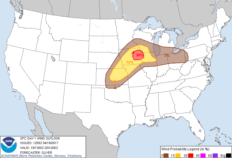
Probabilistic Damaging Wind Graphic
Probability of damaging thunderstorm winds or wind gusts of 50 knots or higher within 25 miles of a point. Hatched Area: 10% of greater probability of wind gusts 65 knots or greater within 25 miles of a point.
Day 1 Wind Risk
Area (sq. mi.)
Area Pop.
Some Larger Population Centers in Risk Area
30 %
13,681
938,739
Cedar Rapids, IA...Waterloo, IA...Iowa City, IA...Dubuque, IA...Cedar Falls, IA...
15 %
111,798
8,889,625
Kansas City, MO...Omaha, NE...Lincoln, NE...Madison, WI...Des Moines, IA...
SPC AC 191259
Day 1 Convective Outlook
NWS Storm Prediction Center Norman OK
0759 AM CDT Wed Apr 19 2017
Valid 191300Z - 201200Z
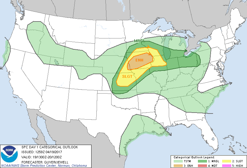
...THERE IS AN ENHANCED RISK OF SEVERE THUNDERSTORMS ACROSS FAR
EASTERN NEBRASKA INTO MUCH OF IOWA...
...THERE IS A SLIGHT RISK OF SEVERE THUNDERSTORMS FROM THE CENTRAL
PLAINS TO THE UPPER MS RIVER VALLEY...
...THERE IS A MARGINAL RISK OF SEVERE THUNDERSTORMS FROM THE
SOUTH-CENTRAL PLAINS TO THE SOUTHERN GREAT LAKES...
...SUMMARY...
Severe thunderstorms capable of large hail, damaging winds, and a
few tornadoes will be possible from the central Plains to the upper
Mississippi Valley mainly from mid-afternoon into tonight.
...Central Plains/middle MO Valley to upper MS Valley...
Embedded within a moderately strong belt of west-southwesterly
mid-level winds, water vapor imagery features an eastward-moving
shortwave trough from WY into the north-central High Plains. This
impulse will continue east-northeastward and reach the Upper Midwest
tonight.
To the north of a roughly west/east-oriented front, bands of
convection (strong in some cases) are ongoing this morning across
eastern NE into southern IA and northwest IL. A few of the stronger
cores could produce hail this morning mainly from far eastern NE
into western IA. On the southern fringes of this early-day
convection and related cloud cover, the air mass is expected to
become moderately unstable (1500-2000 J per kg MLCAPE) late this
afternoon. This will especially be the case across southeast
NE/northeast KS ahead of a southeastward-moving cold front, and
across IA near and south of a northward-shifting warm front. Current
thinking is that surface-based thunderstorms will initially develop
by mid/late afternoon across east/southeast NE and northeast KS into
far western IA.
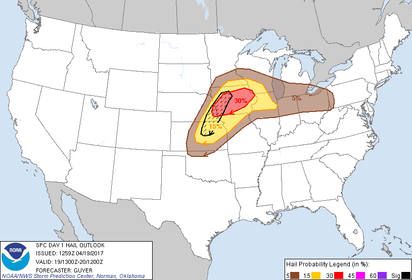
Very steep mid-level lapse rates, moderate buoyancy and
supercell-favorable wind profiles will support the possibility of
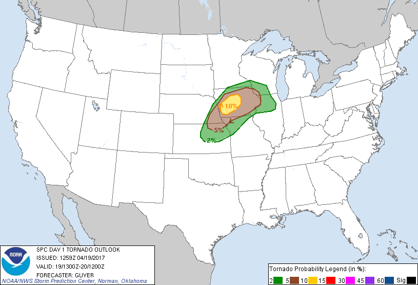
large hail. A tornado risk will also exist late this afternoon into
early/mid-evening, particularly across west/central IA in vicinity
of the northward-spreading effective warm front, where near-50-kt
winds around 1-2 km AGL will contribute to 0-1 km SRH on the order
of 250-300 m2/s2.
As forcing for ascent and low/mid-level winds increase, storms will
expand east/northeastward during the evening and overnight into
additional parts of IA, southern MN and the adjacent upper MS Valley
vicinity, including both elevated storms capable of hail and
near-surface-based storms capable of damaging winds/brief tornado
risk near the north/northeastward-shifting warm front.
Farther south, other severe thunderstorms capable of large hail and
locally damaging winds will persist this evening into the overnight
across KS into western/northern MO near and ahead of the
southeastward-moving cold front.
...Southern Great Lakes to upper OH Valley...
Additional moistening will occur across the region today in advance
of a slow-southeastward-moving front. A weak westerlies-embedded
impulse, related to convection near the IA/IL Quad Cities this
morning, will continue eastward today and have at least some
influence on increasing diurnal convective development this
afternoon from northeast IL into northern portions of IN and OH.
Sufficient heating and destabilization in the presence of around 35
kt of effective shear may support storms capable of isolated severe
hail and locally damaging winds.
..Guyer/Jewell.. 04/19/2017
CLICK TO GET WUUS01 PTSDY1 PRODUCT
NOTE: THE NEXT DAY 1 OUTLOOK IS SCHEDULED BY 1630Z